You are here: Home > Network List > TA - USArray Transportable Network (new EarthScope stations) Stations List
> Station G25K Bearman Lake, AK, USA > Earthquake Result Viewer
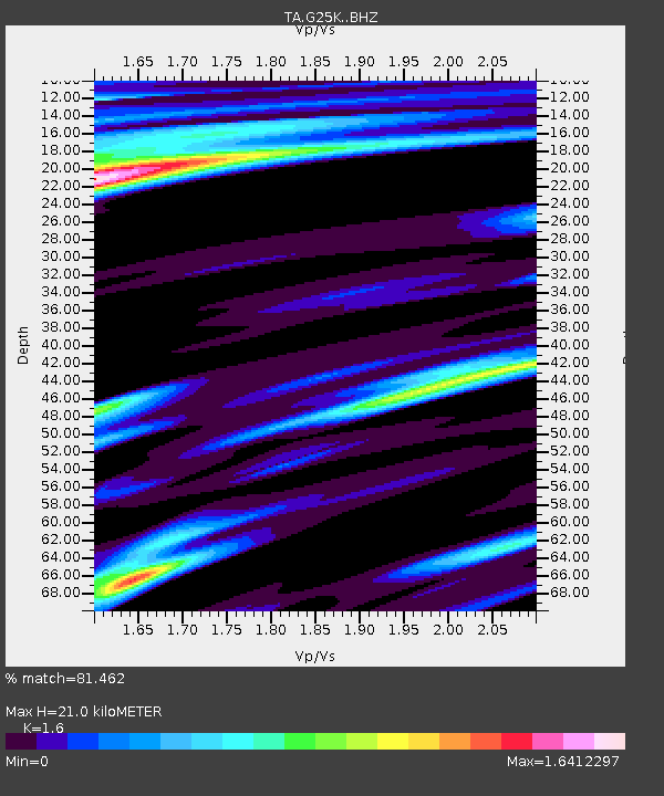
G25K Bearman Lake, AK, USA - Earthquake Result Viewer
| Earthquake location: |
Kuril Islands |
| Earthquake latitude/longitude: |
49.4/156.2 |
| Earthquake time(UTC): |
2018/10/09 (282) 07:45:14 GMT |
| Earthquake Depth: |
42 km |
| Earthquake Magnitude: |
6.0 Mww |
| Earthquake Catalog/Contributor: |
NEIC PDE/us |
|
| Network: |
TA USArray Transportable Network (new EarthScope stations) |
| Station: |
G25K Bearman Lake, AK, USA |
| Lat/Lon: |
66.77 N/146.10 W |
| Elevation: |
146 m |
|
| Distance: |
33.5 deg |
| Az: |
37.393 deg |
| Baz: |
267.979 deg |
| Ray Param: |
0.07808284 |
| Estimated Moho Depth: |
21.0 km |
| Estimated Crust Vp/Vs: |
1.60 |
| Assumed Crust Vp: |
6.522 km/s |
| Estimated Crust Vs: |
4.076 km/s |
| Estimated Crust Poisson's Ratio: |
0.18 |
|
| Radial Match: |
81.462 % |
| Radial Bump: |
388 |
| Transverse Match: |
66.514465 % |
| Transverse Bump: |
383 |
| SOD ConfigId: |
13570011 |
| Insert Time: |
2019-05-01 10:49:14.347 +0000 |
| GWidth: |
2.5 |
| Max Bumps: |
400 |
| Tol: |
0.001 |
|

Signal To Noise
| Channel | StoN | STA | LTA |
| TA:G25K: :BHZ:20181009T07:51:19.400011Z | 7.7948093 | 1.1012652E-6 | 1.4128186E-7 |
| TA:G25K: :BHN:20181009T07:51:19.400011Z | 1.319661 | 6.288825E-7 | 4.765485E-7 |
| TA:G25K: :BHE:20181009T07:51:19.400011Z | 2.089279 | 6.577695E-7 | 3.1483086E-7 |
| Arrivals |
| Ps | 2.1 SECOND |
| PpPs | 7.7 SECOND |
| PsPs/PpSs | 9.8 SECOND |


