You are here: Home > Network List > TA - USArray Transportable Network (new EarthScope stations) Stations List
> Station G27K Doyon Strip, AK, USA > Earthquake Result Viewer
G27K Doyon Strip, AK, USA - Earthquake Result Viewer
| Earthquake location: |
Kuril Islands |
| Earthquake latitude/longitude: |
49.4/156.2 |
| Earthquake time(UTC): |
2018/10/09 (282) 07:45:14 GMT |
| Earthquake Depth: |
42 km |
| Earthquake Magnitude: |
6.0 Mww |
| Earthquake Catalog/Contributor: |
NEIC PDE/us |
|
| Network: |
TA USArray Transportable Network (new EarthScope stations) |
| Station: |
G27K Doyon Strip, AK, USA |
| Lat/Lon: |
66.81 N/141.65 W |
| Elevation: |
686 m |
|
| Distance: |
35.3 deg |
| Az: |
37.317 deg |
| Baz: |
271.998 deg |
| Ray Param: |
0.07720729 |
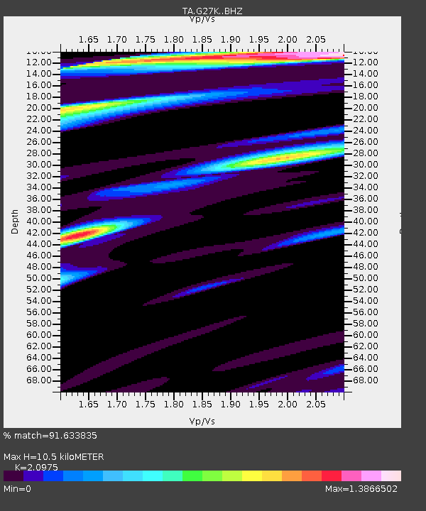
| Estimated Moho Depth: |
10.5 km |
| Estimated Crust Vp/Vs: |
2.10 |
| Assumed Crust Vp: |
6.577 km/s |
| Estimated Crust Vs: |
3.136 km/s |
| Estimated Crust Poisson's Ratio: |
0.35 |
|
| Radial Match: |
91.633835 % |
| Radial Bump: |
400 |
| Transverse Match: |
78.42994 % |
| Transverse Bump: |
400 |
| SOD ConfigId: |
13570011 |
| Insert Time: |
2019-05-01 10:49:14.999 +0000 |
| GWidth: |
2.5 |
| Max Bumps: |
400 |
| Tol: |
0.001 |
|

Signal To Noise
| Channel | StoN | STA | LTA |
| TA:G27K: :BHZ:20181009T07:51:34.599993Z | 8.518203 | 8.053857E-7 | 9.454879E-8 |
| TA:G27K: :BHN:20181009T07:51:34.599993Z | 2.1431296 | 1.3369144E-7 | 6.23814E-8 |
| TA:G27K: :BHE:20181009T07:51:34.599993Z | 4.0869975 | 3.56782E-7 | 8.7296854E-8 |
| Arrivals |
| Ps | 1.9 SECOND |
| PpPs | 4.6 SECOND |
| PsPs/PpSs | 6.5 SECOND |


