You are here: Home > Network List > TA - USArray Transportable Network (new EarthScope stations) Stations List
> Station H29M Whitestone, YT, CAN > Earthquake Result Viewer
H29M Whitestone, YT, CAN - Earthquake Result Viewer
| Earthquake location: |
Kuril Islands |
| Earthquake latitude/longitude: |
49.4/156.2 |
| Earthquake time(UTC): |
2018/10/09 (282) 07:45:14 GMT |
| Earthquake Depth: |
42 km |
| Earthquake Magnitude: |
6.0 Mww |
| Earthquake Catalog/Contributor: |
NEIC PDE/us |
|
| Network: |
TA USArray Transportable Network (new EarthScope stations) |
| Station: |
H29M Whitestone, YT, CAN |
| Lat/Lon: |
66.22 N/138.37 W |
| Elevation: |
480 m |
|
| Distance: |
36.6 deg |
| Az: |
38.172 deg |
| Baz: |
275.701 deg |
| Ray Param: |
0.076472804 |
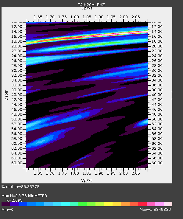
| Estimated Moho Depth: |
13.75 km |
| Estimated Crust Vp/Vs: |
2.10 |
| Assumed Crust Vp: |
6.577 km/s |
| Estimated Crust Vs: |
3.139 km/s |
| Estimated Crust Poisson's Ratio: |
0.35 |
|
| Radial Match: |
86.33778 % |
| Radial Bump: |
400 |
| Transverse Match: |
73.560104 % |
| Transverse Bump: |
400 |
| SOD ConfigId: |
13570011 |
| Insert Time: |
2019-05-01 10:49:23.610 +0000 |
| GWidth: |
2.5 |
| Max Bumps: |
400 |
| Tol: |
0.001 |
|

Signal To Noise
| Channel | StoN | STA | LTA |
| TA:H29M: :BHZ:20181009T07:51:46.175005Z | 6.7145844 | 1.1262368E-6 | 1.6772994E-7 |
| TA:H29M: :BHN:20181009T07:51:46.175005Z | 1.1876595 | 1.6441442E-7 | 1.3843567E-7 |
| TA:H29M: :BHE:20181009T07:51:46.175005Z | 2.6473775 | 5.0253925E-7 | 1.898253E-7 |
| Arrivals |
| Ps | 2.4 SECOND |
| PpPs | 6.1 SECOND |
| PsPs/PpSs | 8.5 SECOND |


