You are here: Home > Network List > TA - USArray Transportable Network (new EarthScope stations) Stations List
> Station P33M Teslin, Yukon, CA > Earthquake Result Viewer
P33M Teslin, Yukon, CA - Earthquake Result Viewer
| Earthquake location: |
Kuril Islands |
| Earthquake latitude/longitude: |
49.4/156.2 |
| Earthquake time(UTC): |
2018/10/09 (282) 07:45:14 GMT |
| Earthquake Depth: |
42 km |
| Earthquake Magnitude: |
6.0 Mww |
| Earthquake Catalog/Contributor: |
NEIC PDE/us |
|
| Network: |
TA USArray Transportable Network (new EarthScope stations) |
| Station: |
P33M Teslin, Yukon, CA |
| Lat/Lon: |
60.21 N/132.82 W |
| Elevation: |
1066 m |
|
| Distance: |
40.3 deg |
| Az: |
46.848 deg |
| Baz: |
287.458 deg |
| Ray Param: |
0.07436845 |
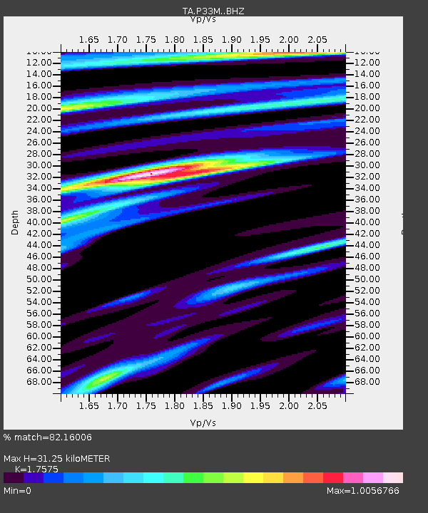
| Estimated Moho Depth: |
31.25 km |
| Estimated Crust Vp/Vs: |
1.76 |
| Assumed Crust Vp: |
6.419 km/s |
| Estimated Crust Vs: |
3.652 km/s |
| Estimated Crust Poisson's Ratio: |
0.26 |
|
| Radial Match: |
82.16006 % |
| Radial Bump: |
381 |
| Transverse Match: |
67.52522 % |
| Transverse Bump: |
400 |
| SOD ConfigId: |
13570011 |
| Insert Time: |
2019-05-01 10:49:54.550 +0000 |
| GWidth: |
2.5 |
| Max Bumps: |
400 |
| Tol: |
0.001 |
|

Signal To Noise
| Channel | StoN | STA | LTA |
| TA:P33M: :BHZ:20181009T07:52:16.999987Z | 3.0168848 | 6.887935E-7 | 2.2831283E-7 |
| TA:P33M: :BHN:20181009T07:52:16.999987Z | 1.902 | 2.797857E-7 | 1.4710079E-7 |
| TA:P33M: :BHE:20181009T07:52:16.999987Z | 2.3042672 | 4.1288706E-7 | 1.7918369E-7 |
| Arrivals |
| Ps | 4.0 SECOND |
| PpPs | 13 SECOND |
| PsPs/PpSs | 16 SECOND |


