You are here: Home > Network List > TJ - Tajikistan National Seismic Network Stations List
> Station GARM Garm, Tajikistan > Earthquake Result Viewer
GARM Garm, Tajikistan - Earthquake Result Viewer

| Earthquake location: |
Kuril Islands |
| Earthquake latitude/longitude: |
49.4/156.2 |
| Earthquake time(UTC): |
2018/10/09 (282) 07:45:14 GMT |
| Earthquake Depth: |
42 km |
| Earthquake Magnitude: |
6.0 Mww |
| Earthquake Catalog/Contributor: |
NEIC PDE/us |
|
| Network: |
TJ Tajikistan National Seismic Network |
| Station: |
GARM Garm, Tajikistan |
| Lat/Lon: |
39.00 N/70.32 E |
| Elevation: |
1305 m |
|
| Distance: |
59.2 deg |
| Az: |
295.25 deg |
| Baz: |
49.274 deg |
| Ray Param: |
0.062235486 |
| Estimated Moho Depth: |
11.0 km |
| Estimated Crust Vp/Vs: |
1.61 |
| Assumed Crust Vp: |
6.306 km/s |
| Estimated Crust Vs: |
3.923 km/s |
| Estimated Crust Poisson's Ratio: |
0.18 |
|
| Radial Match: |
87.47277 % |
| Radial Bump: |
400 |
| Transverse Match: |
84.445915 % |
| Transverse Bump: |
400 |
| SOD ConfigId: |
13570011 |
| Insert Time: |
2019-05-01 10:50:02.268 +0000 |
| GWidth: |
2.5 |
| Max Bumps: |
400 |
| Tol: |
0.001 |
|
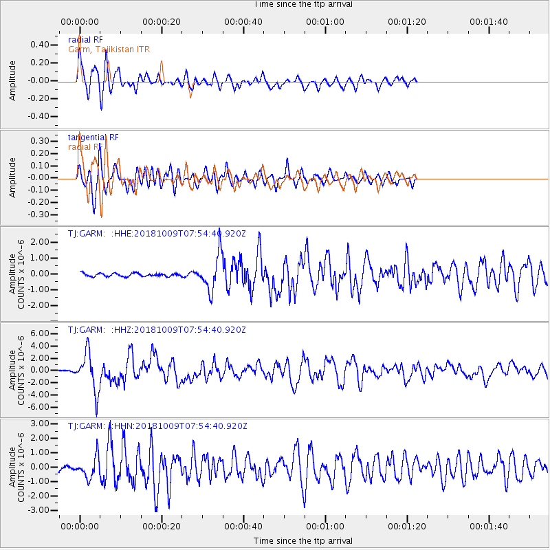
Signal To Noise
| Channel | StoN | STA | LTA |
| TJ:GARM: :HHZ:20181009T07:54:40.920Z | 29.321482 | 3.216205E-6 | 1.0968767E-7 |
| TJ:GARM: :HHN:20181009T07:54:40.920Z | 6.069754 | 7.4152825E-7 | 1.2216775E-7 |
| TJ:GARM: :HHE:20181009T07:54:40.920Z | 12.256877 | 1.2181019E-6 | 9.9381104E-8 |
| Arrivals |
| Ps | 1.1 SECOND |
| PpPs | 4.3 SECOND |
| PsPs/PpSs | 5.4 SECOND |


