You are here: Home > Network List > TA - USArray Transportable Network (new EarthScope stations) Stations List
> Station O18A Roosevelt, UT, USA > Earthquake Result Viewer
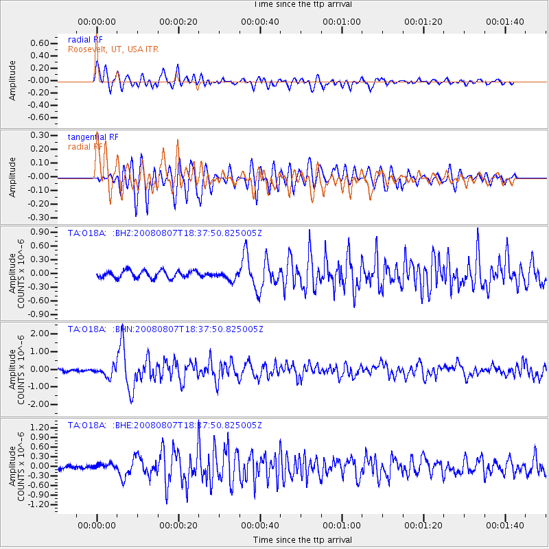
O18A Roosevelt, UT, USA - Earthquake Result Viewer
*The percent match for this event was below the threshold and hence no stack was calculated.
| Earthquake location: |
Andreanof Islands, Aleutian Is. |
| Earthquake latitude/longitude: |
52.2/-175.7 |
| Earthquake time(UTC): |
2008/08/07 (220) 18:30:03 GMT |
| Earthquake Depth: |
12 km |
| Earthquake Magnitude: |
5.6 MB, 5.5 MS, 5.8 MW, 5.8 MW |
| Earthquake Catalog/Contributor: |
WHDF/NEIC |
|
| Network: |
TA USArray Transportable Network (new EarthScope stations) |
| Station: |
O18A Roosevelt, UT, USA |
| Lat/Lon: |
40.27 N/110.01 W |
| Elevation: |
1582 m |
|
| Distance: |
45.4 deg |
| Az: |
78.042 deg |
| Baz: |
308.088 deg |
| Ray Param: |
$rayparam |
*The percent match for this event was below the threshold and hence was not used in the summary stack. |
|
| Radial Match: |
77.1793 % |
| Radial Bump: |
400 |
| Transverse Match: |
77.19212 % |
| Transverse Bump: |
400 |
| SOD ConfigId: |
2504 |
| Insert Time: |
2010-03-06 16:34:16.780 +0000 |
| GWidth: |
2.5 |
| Max Bumps: |
400 |
| Tol: |
0.001 |
|
Signal To Noise
| Channel | StoN | STA | LTA |
| TA:O18A: :BHN:20080807T18:37:50.825005Z | 2.52051 | 2.9403972E-7 | 1.16658825E-7 |
| TA:O18A: :BHE:20080807T18:37:50.825005Z | 1.2170459 | 8.579132E-8 | 7.0491446E-8 |
| TA:O18A: :BHZ:20080807T18:37:50.825005Z | 1.2485093 | 9.968167E-8 | 7.9840554E-8 |
| Arrivals |
| Ps | |
| PpPs | |
| PsPs/PpSs | |


