You are here: Home > Network List > TA - USArray Transportable Network (new EarthScope stations) Stations List
> Station O18A Roosevelt, UT, USA > Earthquake Result Viewer
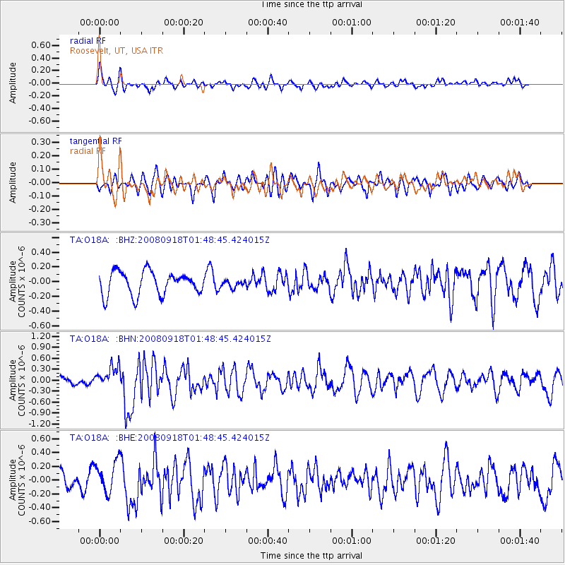
O18A Roosevelt, UT, USA - Earthquake Result Viewer
*The percent match for this event was below the threshold and hence no stack was calculated.
| Earthquake location: |
Central East Pacific Rise |
| Earthquake latitude/longitude: |
-4.6/-106.0 |
| Earthquake time(UTC): |
2008/09/18 (262) 01:41:02 GMT |
| Earthquake Depth: |
10 km |
| Earthquake Magnitude: |
5.5 MB, 5.7 MS, 6.0 MW, 6.0 MW |
| Earthquake Catalog/Contributor: |
WHDF/NEIC |
|
| Network: |
TA USArray Transportable Network (new EarthScope stations) |
| Station: |
O18A Roosevelt, UT, USA |
| Lat/Lon: |
40.27 N/110.01 W |
| Elevation: |
1582 m |
|
| Distance: |
44.8 deg |
| Az: |
355.643 deg |
| Baz: |
174.32 deg |
| Ray Param: |
$rayparam |
*The percent match for this event was below the threshold and hence was not used in the summary stack. |
|
| Radial Match: |
63.008057 % |
| Radial Bump: |
400 |
| Transverse Match: |
57.619335 % |
| Transverse Bump: |
400 |
| SOD ConfigId: |
2560 |
| Insert Time: |
2010-03-06 16:34:23.168 +0000 |
| GWidth: |
2.5 |
| Max Bumps: |
400 |
| Tol: |
0.001 |
|
Signal To Noise
| Channel | StoN | STA | LTA |
| TA:O18A: :BHN:20080918T01:48:45.424015Z | 1.9505537 | 3.022391E-7 | 1.5495043E-7 |
| TA:O18A: :BHE:20080918T01:48:45.424015Z | 1.760343 | 2.281168E-7 | 1.2958657E-7 |
| TA:O18A: :BHZ:20080918T01:48:45.424015Z | 0.3032519 | 4.7901693E-8 | 1.5796009E-7 |
| Arrivals |
| Ps | |
| PpPs | |
| PsPs/PpSs | |


