You are here: Home > Network List > TS - TERRAscope (Southern California Seismic Network) Stations List
> Station BAR Barrett Dam, California, USA > Earthquake Result Viewer
BAR Barrett Dam, California, USA - Earthquake Result Viewer
| Earthquake location: |
Peru-Ecuador Border Region |
| Earthquake latitude/longitude: |
-2.8/-77.9 |
| Earthquake time(UTC): |
1995/10/03 (276) 01:51:24 GMT |
| Earthquake Depth: |
27 km |
| Earthquake Magnitude: |
6.5 MB, 7.0 MS, 6.9 UNKNOWN, 7.0 MW |
| Earthquake Catalog/Contributor: |
WHDF/NEIC |
|
| Network: |
TS TERRAscope (Southern California Seismic Network) |
| Station: |
BAR Barrett Dam, California, USA |
| Lat/Lon: |
32.68 N/116.67 W |
| Elevation: |
548 m |
|
| Distance: |
50.9 deg |
| Az: |
317.092 deg |
| Baz: |
126.258 deg |
| Ray Param: |
0.06771075 |
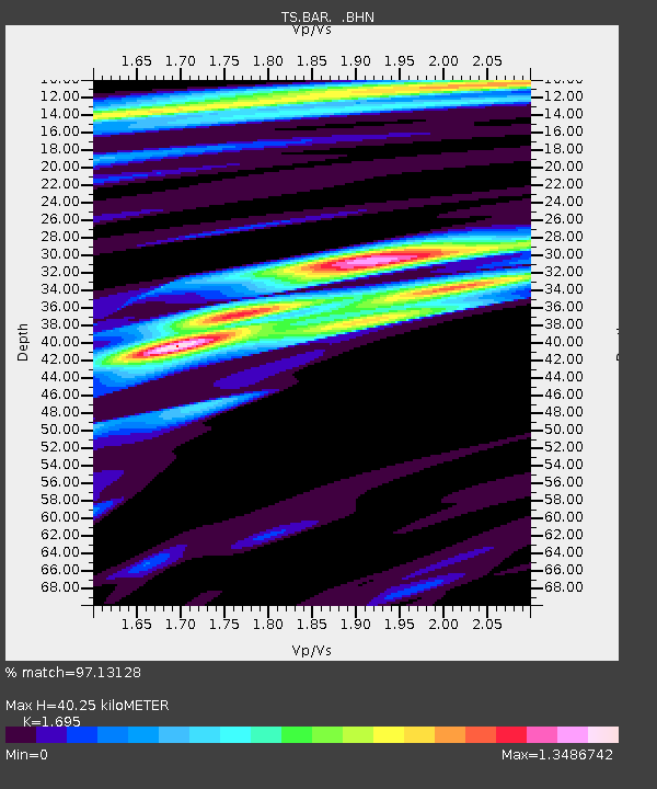
| Estimated Moho Depth: |
40.25 km |
| Estimated Crust Vp/Vs: |
1.70 |
| Assumed Crust Vp: |
6.264 km/s |
| Estimated Crust Vs: |
3.695 km/s |
| Estimated Crust Poisson's Ratio: |
0.23 |
|
| Radial Match: |
97.13128 % |
| Radial Bump: |
326 |
| Transverse Match: |
87.286736 % |
| Transverse Bump: |
400 |
| SOD ConfigId: |
6273 |
| Insert Time: |
2010-02-26 13:57:54.229 +0000 |
| GWidth: |
2.5 |
| Max Bumps: |
400 |
| Tol: |
0.001 |
|
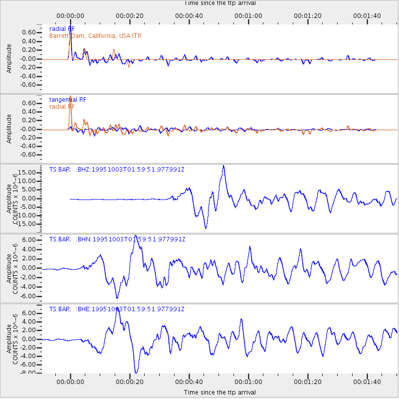
Signal To Noise
| Channel | StoN | STA | LTA |
| TS:BAR: :BHN:19951003T01:59:51.977991Z | 2.873449 | 2.4298254E-7 | 8.456128E-8 |
| TS:BAR: :BHE:19951003T01:59:51.977991Z | 2.1510293 | 1.9333349E-7 | 8.987952E-8 |
| TS:BAR: :BHZ:19951003T01:59:51.977991Z | 5.049073 | 6.312215E-7 | 1.2501731E-7 |
| Arrivals |
| Ps | 4.7 SECOND |
| PpPs | 16 SECOND |
| PsPs/PpSs | 21 SECOND |


