You are here: Home > Network List > TA - USArray Transportable Network (new EarthScope stations) Stations List
> Station O18A Roosevelt, UT, USA > Earthquake Result Viewer
O18A Roosevelt, UT, USA - Earthquake Result Viewer
*The percent match for this event was below the threshold and hence no stack was calculated.
| Earthquake location: |
Galapagos Islands Region |
| Earthquake latitude/longitude: |
2.4/-95.1 |
| Earthquake time(UTC): |
2009/03/15 (074) 03:14:31 GMT |
| Earthquake Depth: |
10 km |
| Earthquake Magnitude: |
5.5 MS, 5.4 MB, 5.8 MW, 5.8 MW |
| Earthquake Catalog/Contributor: |
WHDF/NEIC |
|
| Network: |
TA USArray Transportable Network (new EarthScope stations) |
| Station: |
O18A Roosevelt, UT, USA |
| Lat/Lon: |
40.27 N/110.01 W |
| Elevation: |
1582 m |
|
| Distance: |
40.0 deg |
| Az: |
342.198 deg |
| Baz: |
156.472 deg |
| Ray Param: |
$rayparam |
*The percent match for this event was below the threshold and hence was not used in the summary stack. |
|
| Radial Match: |
78.15059 % |
| Radial Bump: |
400 |
| Transverse Match: |
57.51077 % |
| Transverse Bump: |
400 |
| SOD ConfigId: |
2658 |
| Insert Time: |
2010-03-06 16:34:31.878 +0000 |
| GWidth: |
2.5 |
| Max Bumps: |
400 |
| Tol: |
0.001 |
|
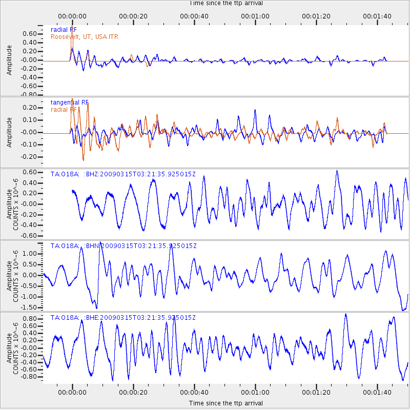
Signal To Noise
| Channel | StoN | STA | LTA |
| TA:O18A: :BHN:20090315T03:21:35.925015Z | 2.0296922 | 6.406377E-7 | 3.1563295E-7 |
| TA:O18A: :BHE:20090315T03:21:35.925015Z | 1.3813244 | 4.1090172E-7 | 2.974694E-7 |
| TA:O18A: :BHZ:20090315T03:21:35.925015Z | 1.2171615 | 2.6685876E-7 | 2.1924681E-7 |
| Arrivals |
| Ps | |
| PpPs | |
| PsPs/PpSs | |


