You are here: Home > Network List > AV - Alaska Volcano Observatory Stations List
> Station AMKA Regional Station, Amchitka Island, Alaska > Earthquake Result Viewer
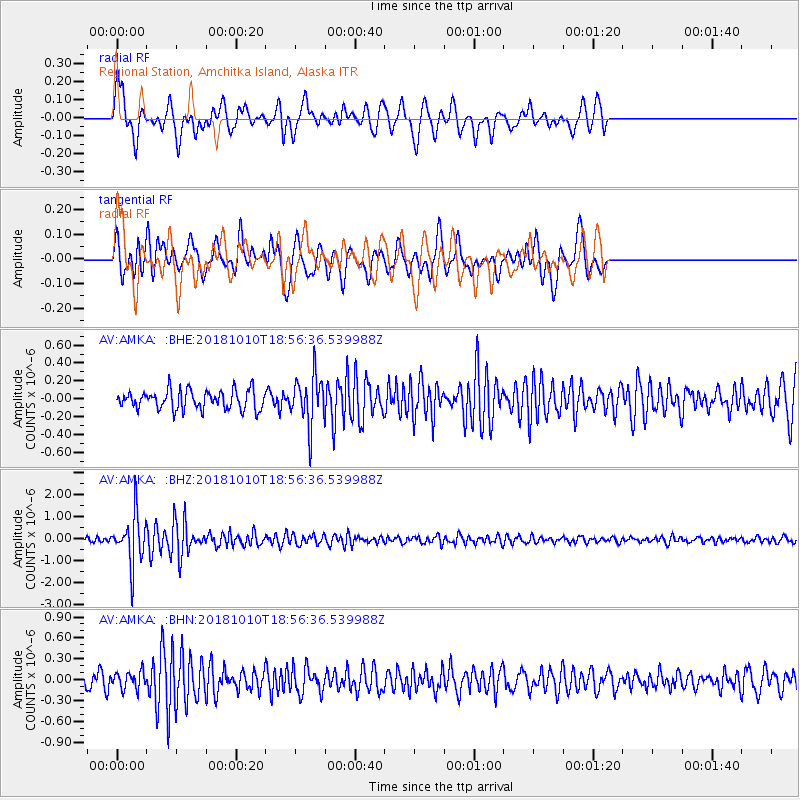
AMKA Regional Station, Amchitka Island, Alaska - Earthquake Result Viewer
*The percent match for this event was below the threshold and hence no stack was calculated.
| Earthquake location: |
Bali Sea |
| Earthquake latitude/longitude: |
-7.4/114.5 |
| Earthquake time(UTC): |
2018/10/10 (283) 18:44:55 GMT |
| Earthquake Depth: |
10 km |
| Earthquake Magnitude: |
6.0 Mww |
| Earthquake Catalog/Contributor: |
NEIC PDE/us |
|
| Network: |
AV Alaska Volcano Observatory |
| Station: |
AMKA Regional Station, Amchitka Island, Alaska |
| Lat/Lon: |
51.38 N/179.30 E |
| Elevation: |
116 m |
|
| Distance: |
80.6 deg |
| Az: |
35.105 deg |
| Baz: |
245.498 deg |
| Ray Param: |
$rayparam |
*The percent match for this event was below the threshold and hence was not used in the summary stack. |
|
| Radial Match: |
72.325874 % |
| Radial Bump: |
400 |
| Transverse Match: |
58.36391 % |
| Transverse Bump: |
400 |
| SOD ConfigId: |
13570011 |
| Insert Time: |
2019-05-01 10:57:35.621 +0000 |
| GWidth: |
2.5 |
| Max Bumps: |
400 |
| Tol: |
0.001 |
|
Signal To Noise
| Channel | StoN | STA | LTA |
| AV:AMKA: :BHZ:20181010T18:56:36.539988Z | 10.196328 | 1.0839375E-6 | 1.0630665E-7 |
| AV:AMKA: :BHN:20181010T18:56:36.539988Z | 1.3430866 | 1.2624562E-7 | 9.399663E-8 |
| AV:AMKA: :BHE:20181010T18:56:36.539988Z | 2.5310946 | 2.7062666E-7 | 1.069208E-7 |
| Arrivals |
| Ps | |
| PpPs | |
| PsPs/PpSs | |


