You are here: Home > Network List > AV - Alaska Volcano Observatory Stations List
> Station MAPS Pakushin Southeast, Makushin Volcano, Alaska > Earthquake Result Viewer
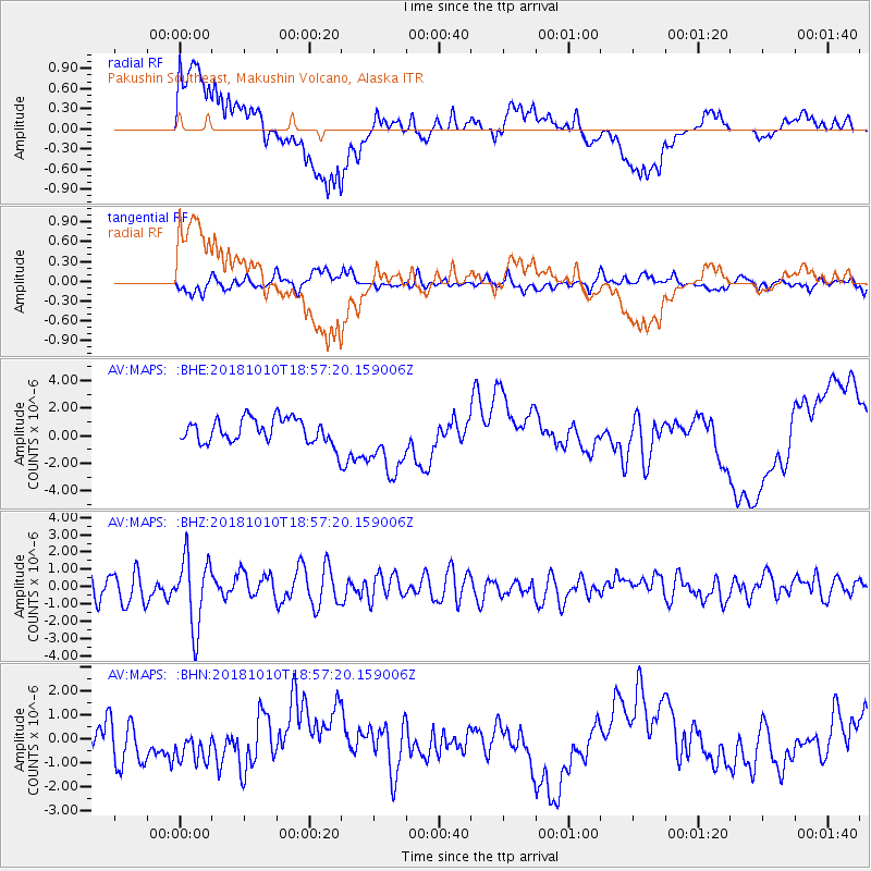
MAPS Pakushin Southeast, Makushin Volcano, Alaska - Earthquake Result Viewer
*The percent match for this event was below the threshold and hence no stack was calculated.
| Earthquake location: |
Bali Sea |
| Earthquake latitude/longitude: |
-7.4/114.5 |
| Earthquake time(UTC): |
2018/10/10 (283) 18:44:55 GMT |
| Earthquake Depth: |
10 km |
| Earthquake Magnitude: |
6.0 Mww |
| Earthquake Catalog/Contributor: |
NEIC PDE/us |
|
| Network: |
AV Alaska Volcano Observatory |
| Station: |
MAPS Pakushin Southeast, Makushin Volcano, Alaska |
| Lat/Lon: |
53.81 N/166.94 W |
| Elevation: |
333 m |
|
| Distance: |
89.3 deg |
| Az: |
35.551 deg |
| Baz: |
256.46 deg |
| Ray Param: |
$rayparam |
*The percent match for this event was below the threshold and hence was not used in the summary stack. |
|
| Radial Match: |
63.715866 % |
| Radial Bump: |
400 |
| Transverse Match: |
55.028244 % |
| Transverse Bump: |
400 |
| SOD ConfigId: |
13570011 |
| Insert Time: |
2019-05-01 10:57:40.562 +0000 |
| GWidth: |
2.5 |
| Max Bumps: |
400 |
| Tol: |
0.001 |
|
Signal To Noise
| Channel | StoN | STA | LTA |
| AV:MAPS: :BHZ:20181010T18:57:20.159006Z | 2.8664303 | 2.0224793E-6 | 7.055742E-7 |
| AV:MAPS: :BHN:20181010T18:57:20.159006Z | 0.9686921 | 7.2465804E-7 | 7.480788E-7 |
| AV:MAPS: :BHE:20181010T18:57:20.159006Z | 2.65046 | 2.4031453E-6 | 9.0668993E-7 |
| Arrivals |
| Ps | |
| PpPs | |
| PsPs/PpSs | |


