You are here: Home > Network List > TA - USArray Transportable Network (new EarthScope stations) Stations List
> Station O18A Roosevelt, UT, USA > Earthquake Result Viewer
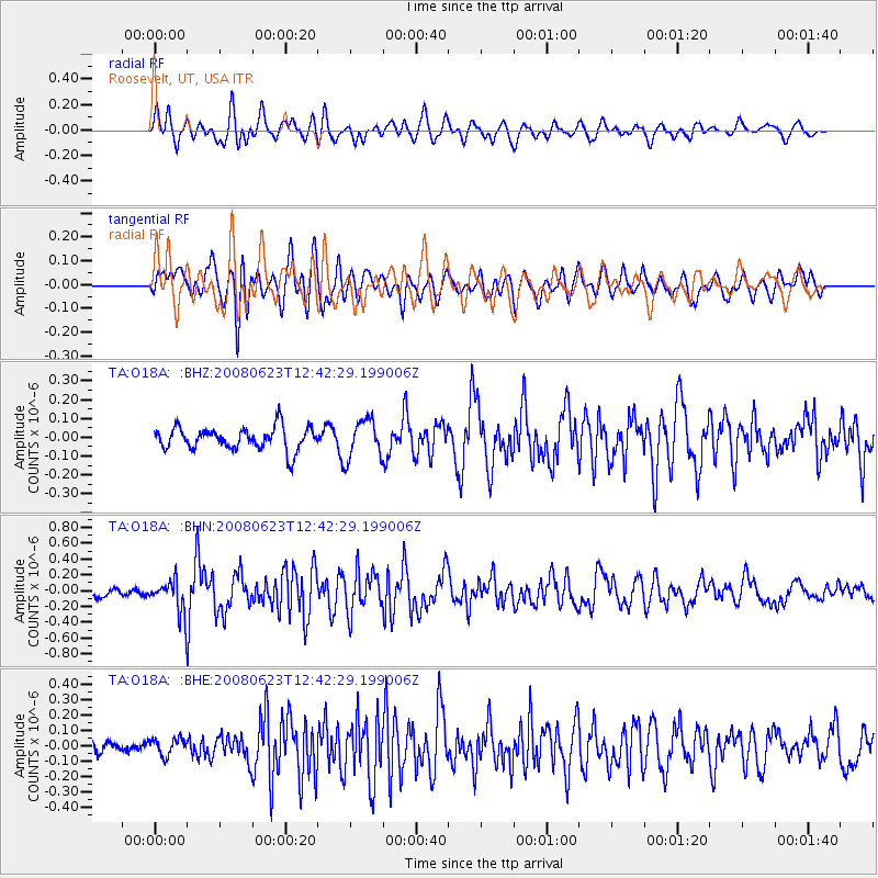
O18A Roosevelt, UT, USA - Earthquake Result Viewer
*The percent match for this event was below the threshold and hence no stack was calculated.
| Earthquake location: |
Kuril Islands |
| Earthquake latitude/longitude: |
46.5/153.3 |
| Earthquake time(UTC): |
2008/06/23 (175) 12:32:12 GMT |
| Earthquake Depth: |
10 km |
| Earthquake Magnitude: |
5.6 MB, 5.2 MS, 5.6 MW, 5.6 MW |
| Earthquake Catalog/Contributor: |
WHDF/NEIC |
|
| Network: |
TA USArray Transportable Network (new EarthScope stations) |
| Station: |
O18A Roosevelt, UT, USA |
| Lat/Lon: |
40.27 N/110.01 W |
| Elevation: |
1582 m |
|
| Distance: |
66.2 deg |
| Az: |
56.152 deg |
| Baz: |
311.409 deg |
| Ray Param: |
$rayparam |
*The percent match for this event was below the threshold and hence was not used in the summary stack. |
|
| Radial Match: |
70.217545 % |
| Radial Bump: |
400 |
| Transverse Match: |
69.58024 % |
| Transverse Bump: |
400 |
| SOD ConfigId: |
2504 |
| Insert Time: |
2010-03-06 16:34:57.132 +0000 |
| GWidth: |
2.5 |
| Max Bumps: |
400 |
| Tol: |
0.001 |
|
Signal To Noise
| Channel | StoN | STA | LTA |
| TA:O18A: :BHN:20080623T12:42:29.199006Z | 3.2984374 | 2.0868602E-7 | 6.3268146E-8 |
| TA:O18A: :BHE:20080623T12:42:29.199006Z | 0.96576405 | 5.4848623E-8 | 5.6792985E-8 |
| TA:O18A: :BHZ:20080623T12:42:29.199006Z | 1.7311106 | 1.0362075E-7 | 5.985796E-8 |
| Arrivals |
| Ps | |
| PpPs | |
| PsPs/PpSs | |


