You are here: Home > Network List > TA - USArray Transportable Network (new EarthScope stations) Stations List
> Station C16K Lisburne Hills, AK, USA > Earthquake Result Viewer
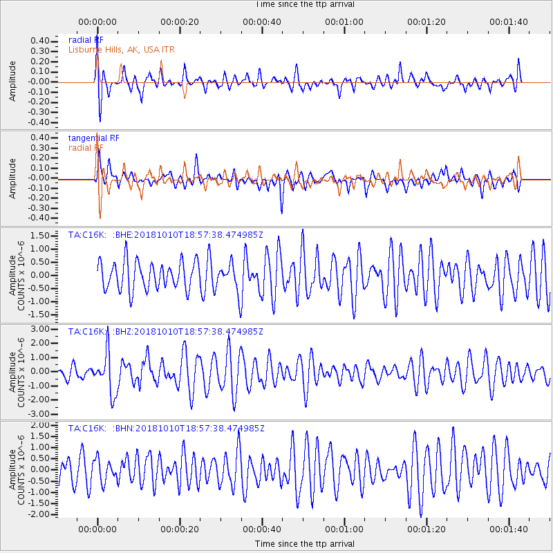
C16K Lisburne Hills, AK, USA - Earthquake Result Viewer
*The percent match for this event was below the threshold and hence no stack was calculated.
| Earthquake location: |
Bali Sea |
| Earthquake latitude/longitude: |
-7.4/114.5 |
| Earthquake time(UTC): |
2018/10/10 (283) 18:44:55 GMT |
| Earthquake Depth: |
10 km |
| Earthquake Magnitude: |
6.0 Mww |
| Earthquake Catalog/Contributor: |
NEIC PDE/us |
|
| Network: |
TA USArray Transportable Network (new EarthScope stations) |
| Station: |
C16K Lisburne Hills, AK, USA |
| Lat/Lon: |
68.27 N/165.34 W |
| Elevation: |
102 m |
|
| Distance: |
93.3 deg |
| Az: |
21.56 deg |
| Baz: |
258.178 deg |
| Ray Param: |
$rayparam |
*The percent match for this event was below the threshold and hence was not used in the summary stack. |
|
| Radial Match: |
61.778908 % |
| Radial Bump: |
400 |
| Transverse Match: |
51.056488 % |
| Transverse Bump: |
400 |
| SOD ConfigId: |
13570011 |
| Insert Time: |
2019-05-01 10:59:54.861 +0000 |
| GWidth: |
2.5 |
| Max Bumps: |
400 |
| Tol: |
0.001 |
|
Signal To Noise
| Channel | StoN | STA | LTA |
| TA:C16K: :BHZ:20181010T18:57:38.474985Z | 2.6331835 | 1.4925639E-6 | 5.668287E-7 |
| TA:C16K: :BHN:20181010T18:57:38.474985Z | 0.73442847 | 4.993498E-7 | 6.7991624E-7 |
| TA:C16K: :BHE:20181010T18:57:38.474985Z | 1.0653408 | 5.567403E-7 | 5.2259367E-7 |
| Arrivals |
| Ps | |
| PpPs | |
| PsPs/PpSs | |


