You are here: Home > Network List > TA - USArray Transportable Network (new EarthScope stations) Stations List
> Station J16A Bone, ID, USA > Earthquake Result Viewer
J16A Bone, ID, USA - Earthquake Result Viewer
| Earthquake location: |
Peru-Brazil Border Region |
| Earthquake latitude/longitude: |
-7.6/-74.4 |
| Earthquake time(UTC): |
2008/08/26 (239) 21:00:36 GMT |
| Earthquake Depth: |
154 km |
| Earthquake Magnitude: |
6.0 MB, 6.4 MW, 6.4 MW |
| Earthquake Catalog/Contributor: |
WHDF/NEIC |
|
| Network: |
TA USArray Transportable Network (new EarthScope stations) |
| Station: |
J16A Bone, ID, USA |
| Lat/Lon: |
43.27 N/111.61 W |
| Elevation: |
2004 m |
|
| Distance: |
60.9 deg |
| Az: |
329.62 deg |
| Baz: |
136.657 deg |
| Ray Param: |
0.06075444 |
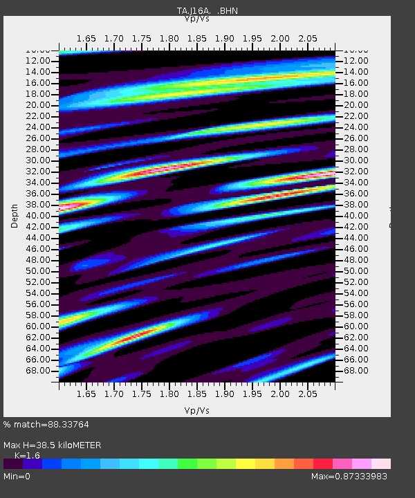
| Estimated Moho Depth: |
38.5 km |
| Estimated Crust Vp/Vs: |
1.60 |
| Assumed Crust Vp: |
6.207 km/s |
| Estimated Crust Vs: |
3.879 km/s |
| Estimated Crust Poisson's Ratio: |
0.18 |
|
| Radial Match: |
88.33764 % |
| Radial Bump: |
400 |
| Transverse Match: |
75.51184 % |
| Transverse Bump: |
400 |
| SOD ConfigId: |
2504 |
| Insert Time: |
2010-03-06 16:35:26.839 +0000 |
| GWidth: |
2.5 |
| Max Bumps: |
400 |
| Tol: |
0.001 |
|

Signal To Noise
| Channel | StoN | STA | LTA |
| TA:J16A: :BHN:20080826T21:10:02.375015Z | 30.405367 | 2.4077767E-6 | 7.91892E-8 |
| TA:J16A: :BHE:20080826T21:10:02.375015Z | 2.827331 | 6.55704E-7 | 2.3191625E-7 |
| TA:J16A: :BHZ:20080826T21:10:02.375015Z | 12.689378 | 8.2282486E-7 | 6.48436E-8 |
| Arrivals |
| Ps | 3.9 SECOND |
| PpPs | 15 SECOND |
| PsPs/PpSs | 19 SECOND |


