You are here: Home > Network List > TA - USArray Transportable Network (new EarthScope stations) Stations List
> Station J16A Bone, ID, USA > Earthquake Result Viewer
J16A Bone, ID, USA - Earthquake Result Viewer
| Earthquake location: |
Tonga Islands |
| Earthquake latitude/longitude: |
-18.4/-175.4 |
| Earthquake time(UTC): |
2008/10/22 (296) 12:55:57 GMT |
| Earthquake Depth: |
233 km |
| Earthquake Magnitude: |
5.9 MB, 6.4 MW, 6.3 MW |
| Earthquake Catalog/Contributor: |
WHDF/NEIC |
|
| Network: |
TA USArray Transportable Network (new EarthScope stations) |
| Station: |
J16A Bone, ID, USA |
| Lat/Lon: |
43.27 N/111.61 W |
| Elevation: |
2004 m |
|
| Distance: |
84.7 deg |
| Az: |
41.133 deg |
| Baz: |
238.77 deg |
| Ray Param: |
0.044722144 |
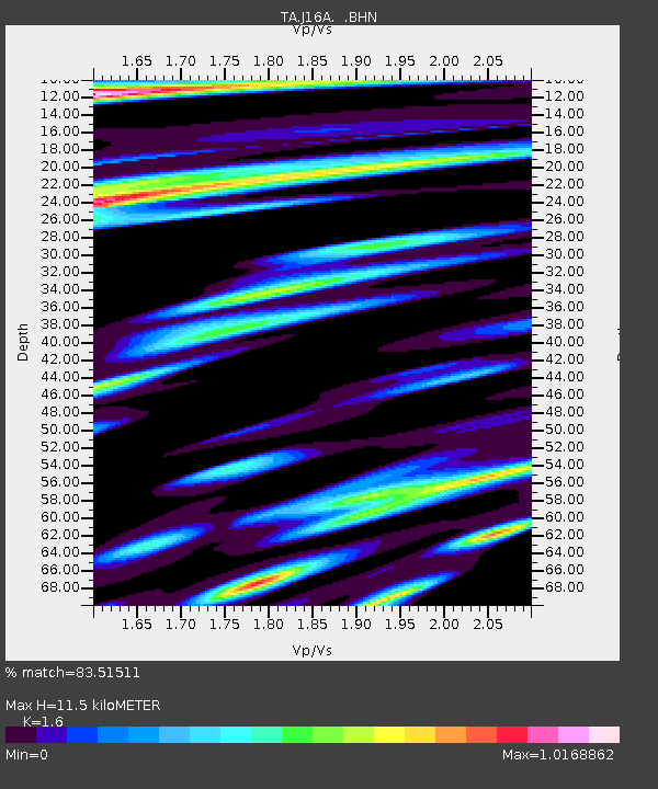
| Estimated Moho Depth: |
11.5 km |
| Estimated Crust Vp/Vs: |
1.60 |
| Assumed Crust Vp: |
6.207 km/s |
| Estimated Crust Vs: |
3.879 km/s |
| Estimated Crust Poisson's Ratio: |
0.18 |
|
| Radial Match: |
83.51511 % |
| Radial Bump: |
400 |
| Transverse Match: |
60.24246 % |
| Transverse Bump: |
400 |
| SOD ConfigId: |
2556 |
| Insert Time: |
2010-03-06 16:35:29.487 +0000 |
| GWidth: |
2.5 |
| Max Bumps: |
400 |
| Tol: |
0.001 |
|
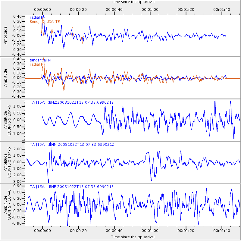
Signal To Noise
| Channel | StoN | STA | LTA |
| TA:J16A: :BHN:20081022T13:07:33.699021Z | 4.2789946 | 1.3716485E-6 | 3.2055394E-7 |
| TA:J16A: :BHE:20081022T13:07:33.699021Z | 1.397669 | 3.718201E-7 | 2.6602874E-7 |
| TA:J16A: :BHZ:20081022T13:07:33.699021Z | 1.7220589 | 4.6311828E-7 | 2.689329E-7 |
| Arrivals |
| Ps | 1.1 SECOND |
| PpPs | 4.7 SECOND |
| PsPs/PpSs | 5.8 SECOND |


