You are here: Home > Network List > TS - TERRAscope (Southern California Seismic Network) Stations List
> Station BAR Barrett Dam, California, USA > Earthquake Result Viewer
BAR Barrett Dam, California, USA - Earthquake Result Viewer
| Earthquake location: |
Near Coast Of Northern Chile |
| Earthquake latitude/longitude: |
-23.4/-70.3 |
| Earthquake time(UTC): |
1995/07/30 (211) 05:11:23 GMT |
| Earthquake Depth: |
47 km |
| Earthquake Magnitude: |
6.6 MB, 7.3 MS, 7.2 UNKNOWN, 8.1 MW |
| Earthquake Catalog/Contributor: |
WHDF/NEIC |
|
| Network: |
TS TERRAscope (Southern California Seismic Network) |
| Station: |
BAR Barrett Dam, California, USA |
| Lat/Lon: |
32.68 N/116.67 W |
| Elevation: |
548 m |
|
| Distance: |
71.2 deg |
| Az: |
319.844 deg |
| Baz: |
135.356 deg |
| Ray Param: |
0.05442475 |
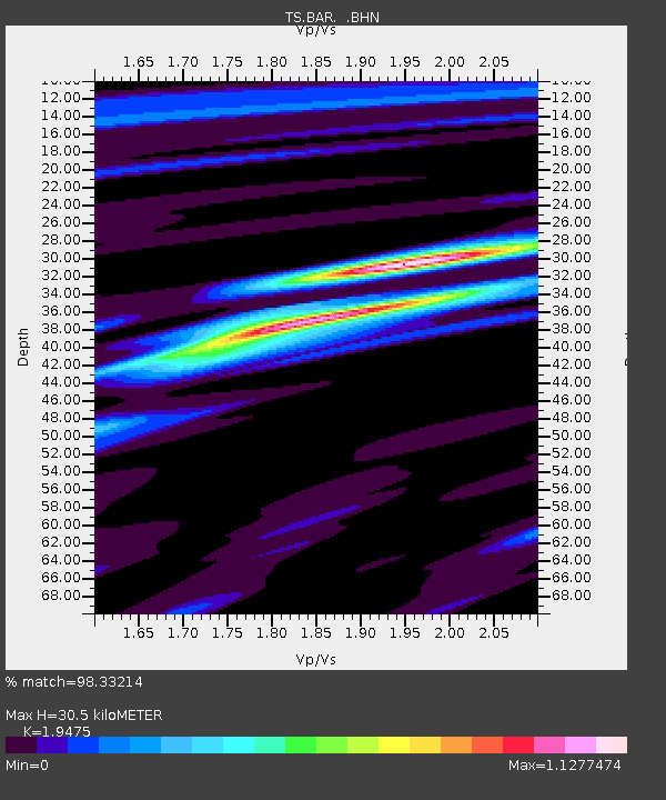
| Estimated Moho Depth: |
30.5 km |
| Estimated Crust Vp/Vs: |
1.95 |
| Assumed Crust Vp: |
6.264 km/s |
| Estimated Crust Vs: |
3.216 km/s |
| Estimated Crust Poisson's Ratio: |
0.32 |
|
| Radial Match: |
98.33214 % |
| Radial Bump: |
329 |
| Transverse Match: |
93.78854 % |
| Transverse Bump: |
400 |
| SOD ConfigId: |
6273 |
| Insert Time: |
2010-02-26 13:57:59.063 +0000 |
| GWidth: |
2.5 |
| Max Bumps: |
400 |
| Tol: |
0.001 |
|
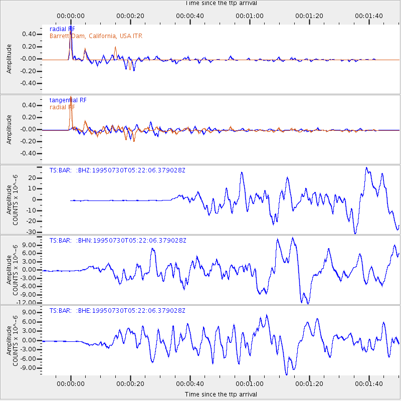
Signal To Noise
| Channel | StoN | STA | LTA |
| TS:BAR: :BHN:19950730T05:22:06.379028Z | 2.6540017 | 2.434505E-7 | 9.1729596E-8 |
| TS:BAR: :BHE:19950730T05:22:06.379028Z | 3.572011 | 2.3674336E-7 | 6.627733E-8 |
| TS:BAR: :BHZ:19950730T05:22:06.379028Z | 6.8441305 | 7.671283E-7 | 1.1208557E-7 |
| Arrivals |
| Ps | 4.8 SECOND |
| PpPs | 14 SECOND |
| PsPs/PpSs | 19 SECOND |


