You are here: Home > Network List > TA - USArray Transportable Network (new EarthScope stations) Stations List
> Station D25K Kavik River, AK, USA > Earthquake Result Viewer
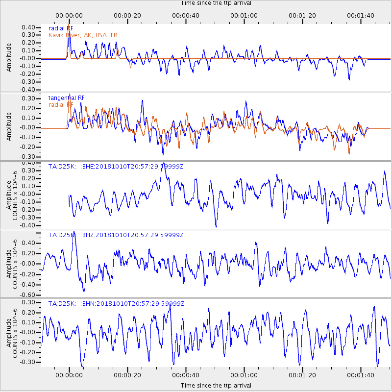
D25K Kavik River, AK, USA - Earthquake Result Viewer
*The percent match for this event was below the threshold and hence no stack was calculated.
| Earthquake location: |
New Britain Region, P.N.G. |
| Earthquake latitude/longitude: |
-5.8/151.3 |
| Earthquake time(UTC): |
2018/10/10 (283) 20:45:26 GMT |
| Earthquake Depth: |
52 km |
| Earthquake Magnitude: |
5.9 mb |
| Earthquake Catalog/Contributor: |
NEIC PDE/us |
|
| Network: |
TA USArray Transportable Network (new EarthScope stations) |
| Station: |
D25K Kavik River, AK, USA |
| Lat/Lon: |
69.32 N/146.38 W |
| Elevation: |
770 m |
|
| Distance: |
85.9 deg |
| Az: |
18.377 deg |
| Baz: |
242.023 deg |
| Ray Param: |
$rayparam |
*The percent match for this event was below the threshold and hence was not used in the summary stack. |
|
| Radial Match: |
70.64089 % |
| Radial Bump: |
400 |
| Transverse Match: |
51.859177 % |
| Transverse Bump: |
400 |
| SOD ConfigId: |
13570011 |
| Insert Time: |
2019-05-01 11:05:30.002 +0000 |
| GWidth: |
2.5 |
| Max Bumps: |
400 |
| Tol: |
0.001 |
|
Signal To Noise
| Channel | StoN | STA | LTA |
| TA:D25K: :BHZ:20181010T20:57:29.59999Z | 2.8402886 | 3.2564085E-7 | 1.1465063E-7 |
| TA:D25K: :BHN:20181010T20:57:29.59999Z | 1.500261 | 1.7866223E-7 | 1.1908744E-7 |
| TA:D25K: :BHE:20181010T20:57:29.59999Z | 3.875664 | 3.2093754E-7 | 8.28084E-8 |
| Arrivals |
| Ps | |
| PpPs | |
| PsPs/PpSs | |


