You are here: Home > Network List > TA - USArray Transportable Network (new EarthScope stations) Stations List
> Station G31M Satah River, YT, CAN > Earthquake Result Viewer
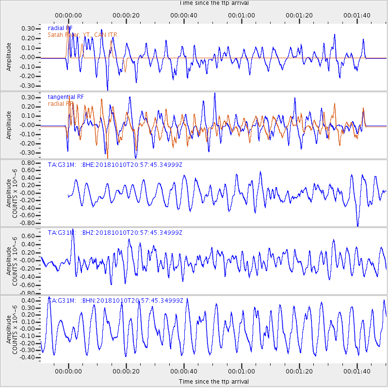
G31M Satah River, YT, CAN - Earthquake Result Viewer
*The percent match for this event was below the threshold and hence no stack was calculated.
| Earthquake location: |
New Britain Region, P.N.G. |
| Earthquake latitude/longitude: |
-5.8/151.3 |
| Earthquake time(UTC): |
2018/10/10 (283) 20:45:26 GMT |
| Earthquake Depth: |
52 km |
| Earthquake Magnitude: |
5.9 mb |
| Earthquake Catalog/Contributor: |
NEIC PDE/us |
|
| Network: |
TA USArray Transportable Network (new EarthScope stations) |
| Station: |
G31M Satah River, YT, CAN |
| Lat/Lon: |
66.92 N/134.27 W |
| Elevation: |
61 m |
|
| Distance: |
89.2 deg |
| Az: |
22.316 deg |
| Baz: |
253.42 deg |
| Ray Param: |
$rayparam |
*The percent match for this event was below the threshold and hence was not used in the summary stack. |
|
| Radial Match: |
52.86009 % |
| Radial Bump: |
400 |
| Transverse Match: |
48.82379 % |
| Transverse Bump: |
318 |
| SOD ConfigId: |
13570011 |
| Insert Time: |
2019-05-01 11:05:40.140 +0000 |
| GWidth: |
2.5 |
| Max Bumps: |
400 |
| Tol: |
0.001 |
|
Signal To Noise
| Channel | StoN | STA | LTA |
| TA:G31M: :BHZ:20181010T20:57:45.34999Z | 2.9901674 | 3.0281066E-7 | 1.01268796E-7 |
| TA:G31M: :BHN:20181010T20:57:45.34999Z | 0.57206714 | 1.2918656E-7 | 2.2582412E-7 |
| TA:G31M: :BHE:20181010T20:57:45.34999Z | 1.2092794 | 2.1193587E-7 | 1.7525798E-7 |
| Arrivals |
| Ps | |
| PpPs | |
| PsPs/PpSs | |


