You are here: Home > Network List > TA - USArray Transportable Network (new EarthScope stations) Stations List
> Station J30M Hart River, Yukon, CAN > Earthquake Result Viewer
J30M Hart River, Yukon, CAN - Earthquake Result Viewer
| Earthquake location: |
New Britain Region, P.N.G. |
| Earthquake latitude/longitude: |
-5.8/151.3 |
| Earthquake time(UTC): |
2018/10/10 (283) 20:45:26 GMT |
| Earthquake Depth: |
52 km |
| Earthquake Magnitude: |
5.9 mb |
| Earthquake Catalog/Contributor: |
NEIC PDE/us |
|
| Network: |
TA USArray Transportable Network (new EarthScope stations) |
| Station: |
J30M Hart River, Yukon, CAN |
| Lat/Lon: |
64.58 N/136.33 W |
| Elevation: |
1419 m |
|
| Distance: |
87.7 deg |
| Az: |
24.309 deg |
| Baz: |
251.597 deg |
| Ray Param: |
0.04304991 |
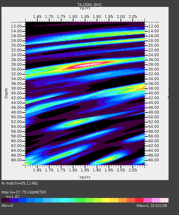
| Estimated Moho Depth: |
27.75 km |
| Estimated Crust Vp/Vs: |
1.87 |
| Assumed Crust Vp: |
6.566 km/s |
| Estimated Crust Vs: |
3.511 km/s |
| Estimated Crust Poisson's Ratio: |
0.30 |
|
| Radial Match: |
85.11461 % |
| Radial Bump: |
400 |
| Transverse Match: |
50.29527 % |
| Transverse Bump: |
400 |
| SOD ConfigId: |
13570011 |
| Insert Time: |
2019-05-01 11:05:47.812 +0000 |
| GWidth: |
2.5 |
| Max Bumps: |
400 |
| Tol: |
0.001 |
|

Signal To Noise
| Channel | StoN | STA | LTA |
| TA:J30M: :BHZ:20181010T20:57:38.175002Z | 2.730775 | 2.724824E-7 | 9.978207E-8 |
| TA:J30M: :BHN:20181010T20:57:38.175002Z | 1.1886951 | 1.6453758E-7 | 1.3841866E-7 |
| TA:J30M: :BHE:20181010T20:57:38.175002Z | 1.65644 | 1.17284834E-7 | 7.080536E-8 |
| Arrivals |
| Ps | 3.8 SECOND |
| PpPs | 12 SECOND |
| PsPs/PpSs | 16 SECOND |


