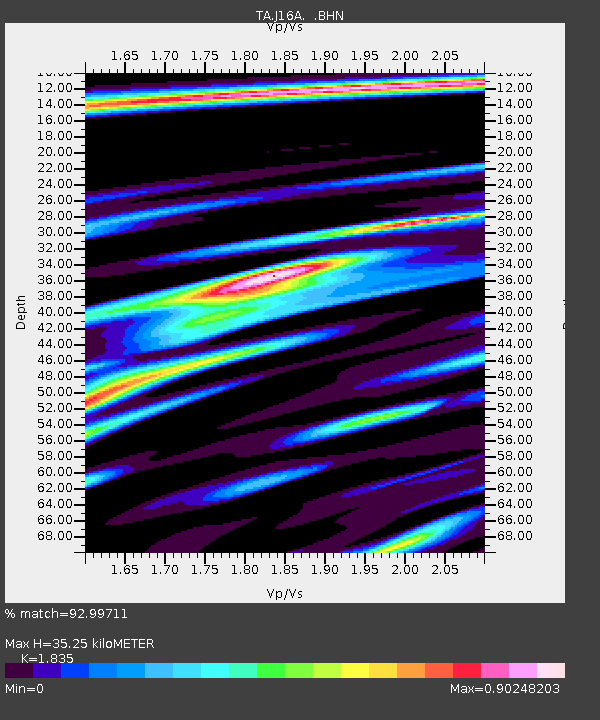
J16A Bone, ID, USA - Earthquake Result Viewer

Earthquake location: Andreanof Islands, Aleutian Is.
Earthquake latitude/longitude: 50.3/-177.5
Earthquake time(UTC): 2007/08/15 (227) 20:22:11 GMT
Earthquake Depth: 9.0 km
Earthquake Magnitude: 6.3 MB, 6.2 MS, 6.4 MW, 5.9 ML
Earthquake Catalog/Contributor: WHDF/NEIC
Network: TA USArray Transportable Network (new EarthScope stations)
Station: J16A Bone, ID, USA
Lat/Lon: 43.27 N/111.61 W
Elevation: 2004 m
Distance: 44.3 deg
Az: 72.579 deg
Baz: 303.135 deg
Ray Param: 0.07197722
Estimated Moho Depth: 35.25 km
Estimated Crust Vp/Vs: 1.84
Assumed Crust Vp: 6.207 km/s
Estimated Crust Vs: 3.382 km/s
Estimated Crust Poisson's Ratio: 0.29
Radial Match: 92.99711 %
Radial Bump: 400
Transverse Match: 73.092415 %
Transverse Bump: 400
SOD ConfigId: 2564
Insert Time: 2010-03-06 16:36:17.756 +0000
GWidth: 2.5
Max Bumps: 400
Tol: 0.001

Signal To Noise

ChannelStoNSTALTA
TA:J16A: :BHN:20070815T20:29:50.600011Z4.47268.967511E-72.0049883E-7
TA:J16A: :BHE:20070815T20:29:50.600011Z5.9633741.3954649E-62.3400592E-7
TA:J16A: :BHZ:20070815T20:29:50.600011Z20.9195882.6050345E-61.245261E-7
Arrivals
Ps5.0 SECOND
PpPs15 SECOND
PsPs/PpSs20 SECOND