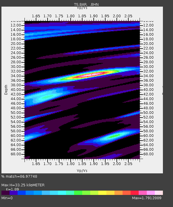
BAR Barrett Dam, California, USA - Earthquake Result Viewer
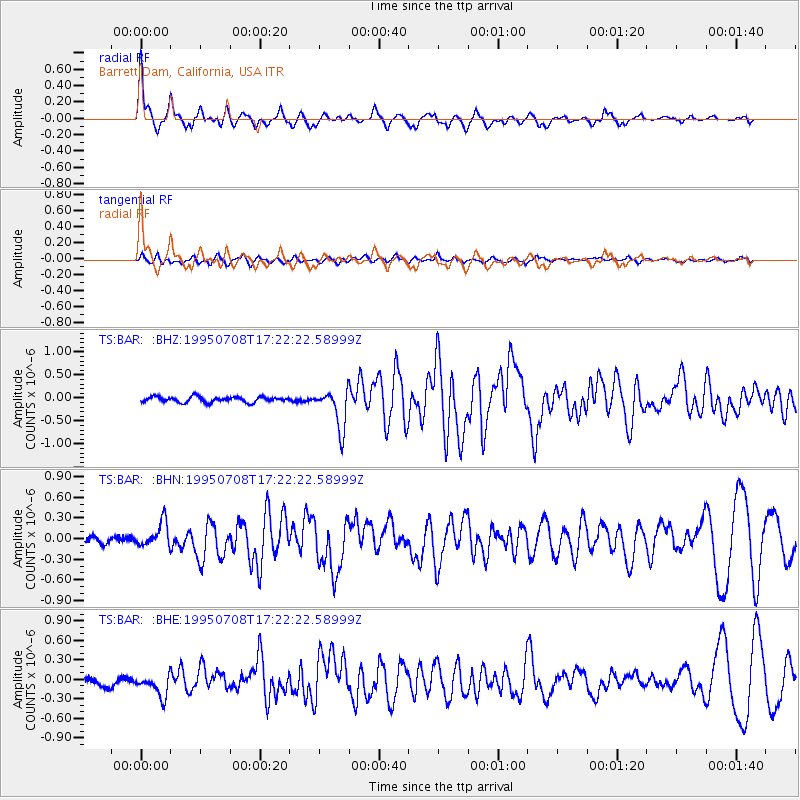
Earthquake location: Unimak Island Region, Alaska
Earthquake latitude/longitude: 53.6/-163.5
Earthquake time(UTC): 1995/07/08 (189) 17:15:28 GMT
Earthquake Depth: 33 km
Earthquake Magnitude: 5.8 MB, 5.7 MS, 5.5 UNKNOWN, 6.0 MW
Earthquake Catalog/Contributor: WHDF/NEIC
Network: TS TERRAscope (Southern California Seismic Network)
Station: BAR Barrett Dam, California, USA
Lat/Lon: 32.68 N/116.67 W
Elevation: 548 m
Distance: 39.2 deg
Az: 103.104 deg
Baz: 316.562 deg
Ray Param: 0.0750609
Estimated Moho Depth: 33.25 km
Estimated Crust Vp/Vs: 1.89
Assumed Crust Vp: 6.264 km/s
Estimated Crust Vs: 3.314 km/s
Estimated Crust Poisson's Ratio: 0.31
Radial Match: 86.97748 %
Radial Bump: 400
Transverse Match: 68.25165 %
Transverse Bump: 400
SOD ConfigId: 6273
Insert Time: 2010-02-26 13:58:00.837 +0000
GWidth: 2.5
Max Bumps: 400
Tol: 0.001

Signal To Noise

ChannelStoNSTALTA
TS:BAR: :BHN:19950708T17:22:22.58999Z3.8640161.8066206E-74.6754995E-8
TS:BAR: :BHE:19950708T17:22:22.58999Z2.76998111.6056502E-75.796611E-8
TS:BAR: :BHZ:19950708T17:22:22.58999Z7.0877574.2346048E-75.974535E-8
Arrivals
Ps5.0 SECOND
PpPs14 SECOND
PsPs/PpSs19 SECOND