You are here: Home > Network List > TA - USArray Transportable Network (new EarthScope stations) Stations List
> Station J16A Bone, ID, USA > Earthquake Result Viewer
J16A Bone, ID, USA - Earthquake Result Viewer

| Earthquake location: |
Sea Of Okhotsk |
| Earthquake latitude/longitude: |
53.9/152.9 |
| Earthquake time(UTC): |
2008/07/05 (187) 02:12:04 GMT |
| Earthquake Depth: |
633 km |
| Earthquake Magnitude: |
6.8 MB, 7.7 MW, 7.7 MW |
| Earthquake Catalog/Contributor: |
WHDF/NEIC |
|
| Network: |
TA USArray Transportable Network (new EarthScope stations) |
| Station: |
J16A Bone, ID, USA |
| Lat/Lon: |
43.27 N/111.61 W |
| Elevation: |
2004 m |
|
| Distance: |
59.4 deg |
| Az: |
57.631 deg |
| Baz: |
316.793 deg |
| Ray Param: |
0.05959456 |
| Estimated Moho Depth: |
32.75 km |
| Estimated Crust Vp/Vs: |
1.96 |
| Assumed Crust Vp: |
6.207 km/s |
| Estimated Crust Vs: |
3.171 km/s |
| Estimated Crust Poisson's Ratio: |
0.32 |
|
| Radial Match: |
89.55839 % |
| Radial Bump: |
400 |
| Transverse Match: |
89.01218 % |
| Transverse Bump: |
400 |
| SOD ConfigId: |
2504 |
| Insert Time: |
2010-03-06 16:36:40.381 +0000 |
| GWidth: |
2.5 |
| Max Bumps: |
400 |
| Tol: |
0.001 |
|
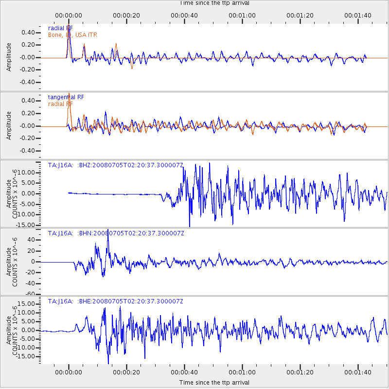
Signal To Noise
| Channel | StoN | STA | LTA |
| TA:J16A: :BHN:20080705T02:20:37.300007Z | 31.611761 | 4.13589E-6 | 1.3083388E-7 |
| TA:J16A: :BHE:20080705T02:20:37.300007Z | 7.6033216 | 1.3322176E-6 | 1.752152E-7 |
| TA:J16A: :BHZ:20080705T02:20:37.300007Z | 7.058493 | 1.3665757E-6 | 1.936073E-7 |
| Arrivals |
| Ps | 5.2 SECOND |
| PpPs | 15 SECOND |
| PsPs/PpSs | 20 SECOND |


