You are here: Home > Network List > AU - Australian Seismological Centre Stations List
> Station NWAO Narrogin, Western Australia > Earthquake Result Viewer
NWAO Narrogin, Western Australia - Earthquake Result Viewer
| Earthquake location: |
New Britain Region, P.N.G. |
| Earthquake latitude/longitude: |
-5.9/151.4 |
| Earthquake time(UTC): |
2018/10/10 (283) 20:48:20 GMT |
| Earthquake Depth: |
33 km |
| Earthquake Magnitude: |
7.3 Mi |
| Earthquake Catalog/Contributor: |
NEIC PDE/at |
|
| Network: |
AU Australian Seismological Centre |
| Station: |
NWAO Narrogin, Western Australia |
| Lat/Lon: |
32.93 S/117.24 E |
| Elevation: |
265 m |
|
| Distance: |
41.6 deg |
| Az: |
225.313 deg |
| Baz: |
57.239 deg |
| Ray Param: |
0.073606566 |
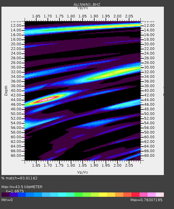
| Estimated Moho Depth: |
43.5 km |
| Estimated Crust Vp/Vs: |
1.70 |
| Assumed Crust Vp: |
6.419 km/s |
| Estimated Crust Vs: |
3.782 km/s |
| Estimated Crust Poisson's Ratio: |
0.23 |
|
| Radial Match: |
93.81162 % |
| Radial Bump: |
291 |
| Transverse Match: |
90.22027 % |
| Transverse Bump: |
400 |
| SOD ConfigId: |
13570011 |
| Insert Time: |
2019-05-01 11:09:32.881 +0000 |
| GWidth: |
2.5 |
| Max Bumps: |
400 |
| Tol: |
0.001 |
|

Signal To Noise
| Channel | StoN | STA | LTA |
| AU:NWAO: :BHZ:20181010T20:55:34.149994Z | 4.079365 | 6.731541E-6 | 1.6501444E-6 |
| AU:NWAO: :BH1:20181010T20:55:34.149994Z | 2.7353556 | 2.2080967E-6 | 8.07243E-7 |
| AU:NWAO: :BH2:20181010T20:55:34.149994Z | 3.7391763 | 3.6172585E-6 | 9.673945E-7 |
| Arrivals |
| Ps | 5.1 SECOND |
| PpPs | 17 SECOND |
| PsPs/PpSs | 22 SECOND |


