You are here: Home > Network List > CI - Caltech Regional Seismic Network Stations List
> Station MPM Manuel Prospect Mine, California, USA > Earthquake Result Viewer
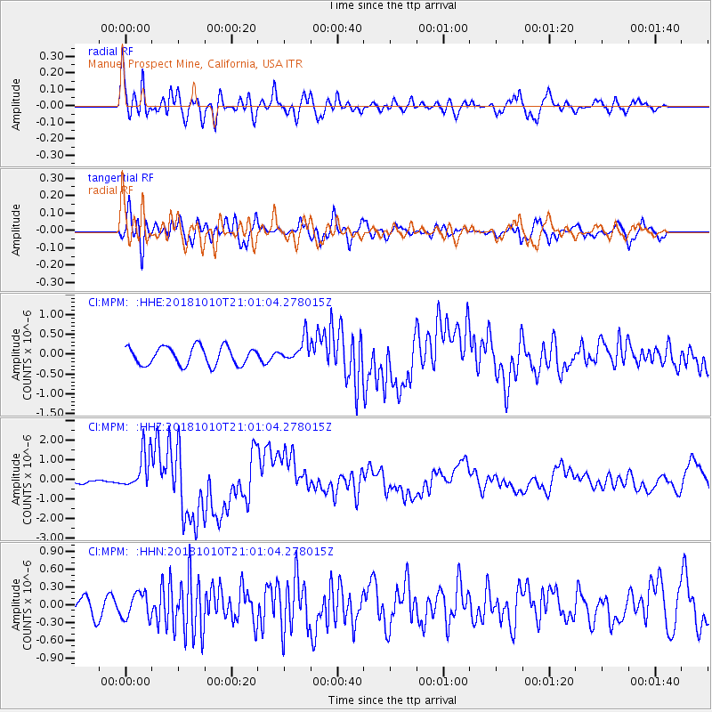
MPM Manuel Prospect Mine, California, USA - Earthquake Result Viewer
*The percent match for this event was below the threshold and hence no stack was calculated.
| Earthquake location: |
New Britain Region, P.N.G. |
| Earthquake latitude/longitude: |
-5.9/151.4 |
| Earthquake time(UTC): |
2018/10/10 (283) 20:48:20 GMT |
| Earthquake Depth: |
33 km |
| Earthquake Magnitude: |
7.3 Mi |
| Earthquake Catalog/Contributor: |
NEIC PDE/at |
|
| Network: |
CI Caltech Regional Seismic Network |
| Station: |
MPM Manuel Prospect Mine, California, USA |
| Lat/Lon: |
36.06 N/117.49 W |
| Elevation: |
185 m |
|
| Distance: |
94.3 deg |
| Az: |
54.337 deg |
| Baz: |
265.892 deg |
| Ray Param: |
$rayparam |
*The percent match for this event was below the threshold and hence was not used in the summary stack. |
|
| Radial Match: |
85.04023 % |
| Radial Bump: |
400 |
| Transverse Match: |
69.85684 % |
| Transverse Bump: |
400 |
| SOD ConfigId: |
13570011 |
| Insert Time: |
2019-05-01 11:11:15.272 +0000 |
| GWidth: |
2.5 |
| Max Bumps: |
400 |
| Tol: |
0.001 |
|
Signal To Noise
| Channel | StoN | STA | LTA |
| CI:MPM: :HHZ:20181010T21:01:04.278015Z | 3.7947874 | 9.921768E-7 | 2.6145779E-7 |
| CI:MPM: :HHN:20181010T21:01:04.278015Z | 1.1089722 | 2.1599867E-7 | 1.9477375E-7 |
| CI:MPM: :HHE:20181010T21:01:04.278015Z | 1.4014671 | 3.1670675E-7 | 2.259823E-7 |
| Arrivals |
| Ps | |
| PpPs | |
| PsPs/PpSs | |


