You are here: Home > Network List > CI - Caltech Regional Seismic Network Stations List
> Station SWS Sam W. Stewart, Westmorland, CA, USA > Earthquake Result Viewer
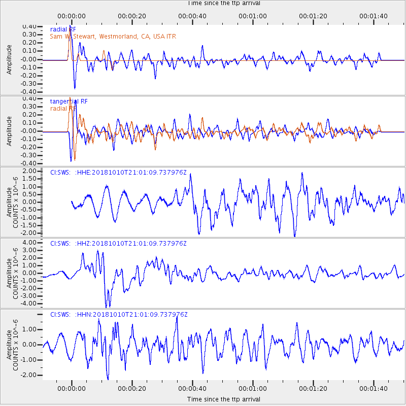
SWS Sam W. Stewart, Westmorland, CA, USA - Earthquake Result Viewer
*The percent match for this event was below the threshold and hence no stack was calculated.
| Earthquake location: |
New Britain Region, P.N.G. |
| Earthquake latitude/longitude: |
-5.9/151.4 |
| Earthquake time(UTC): |
2018/10/10 (283) 20:48:20 GMT |
| Earthquake Depth: |
33 km |
| Earthquake Magnitude: |
7.3 Mi |
| Earthquake Catalog/Contributor: |
NEIC PDE/at |
|
| Network: |
CI Caltech Regional Seismic Network |
| Station: |
SWS Sam W. Stewart, Westmorland, CA, USA |
| Lat/Lon: |
32.94 N/115.80 W |
| Elevation: |
140 m |
|
| Distance: |
95.5 deg |
| Az: |
57.543 deg |
| Baz: |
266.571 deg |
| Ray Param: |
$rayparam |
*The percent match for this event was below the threshold and hence was not used in the summary stack. |
|
| Radial Match: |
81.04974 % |
| Radial Bump: |
400 |
| Transverse Match: |
75.82251 % |
| Transverse Bump: |
400 |
| SOD ConfigId: |
13570011 |
| Insert Time: |
2019-05-01 11:11:28.240 +0000 |
| GWidth: |
2.5 |
| Max Bumps: |
400 |
| Tol: |
0.001 |
|
Signal To Noise
| Channel | StoN | STA | LTA |
| CI:SWS: :HHZ:20181010T21:01:09.737976Z | 2.5665865 | 1.0985475E-6 | 4.2801892E-7 |
| CI:SWS: :HHN:20181010T21:01:09.737976Z | 2.6975918 | 7.057935E-7 | 2.6163838E-7 |
| CI:SWS: :HHE:20181010T21:01:09.737976Z | 0.63328993 | 3.3262168E-7 | 5.2522813E-7 |
| Arrivals |
| Ps | |
| PpPs | |
| PsPs/PpSs | |


