You are here: Home > Network List > TA - USArray Transportable Network (new EarthScope stations) Stations List
> Station J16A Bone, ID, USA > Earthquake Result Viewer
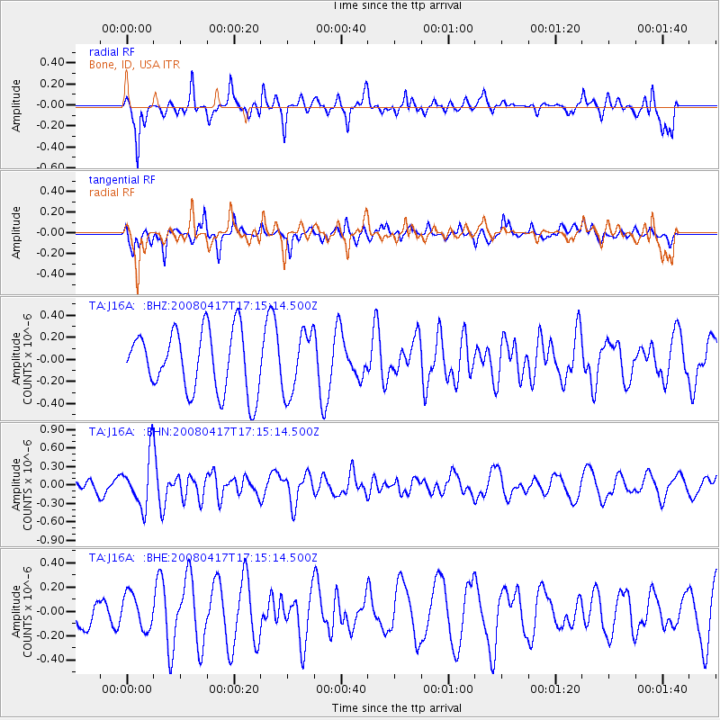
J16A Bone, ID, USA - Earthquake Result Viewer
*The percent match for this event was below the threshold and hence no stack was calculated.
| Earthquake location: |
Mariana Islands Region |
| Earthquake latitude/longitude: |
15.9/144.9 |
| Earthquake time(UTC): |
2008/04/17 (108) 17:02:52 GMT |
| Earthquake Depth: |
10 km |
| Earthquake Magnitude: |
5.5 MB, 5.2 MS, 5.5 MW, 5.5 MW |
| Earthquake Catalog/Contributor: |
WHDF/NEIC |
|
| Network: |
TA USArray Transportable Network (new EarthScope stations) |
| Station: |
J16A Bone, ID, USA |
| Lat/Lon: |
43.27 N/111.61 W |
| Elevation: |
2004 m |
|
| Distance: |
88.8 deg |
| Az: |
45.262 deg |
| Baz: |
290.628 deg |
| Ray Param: |
$rayparam |
*The percent match for this event was below the threshold and hence was not used in the summary stack. |
|
| Radial Match: |
67.33205 % |
| Radial Bump: |
400 |
| Transverse Match: |
58.07352 % |
| Transverse Bump: |
362 |
| SOD ConfigId: |
2504 |
| Insert Time: |
2010-03-06 16:37:34.335 +0000 |
| GWidth: |
2.5 |
| Max Bumps: |
400 |
| Tol: |
0.001 |
|
Signal To Noise
| Channel | StoN | STA | LTA |
| TA:J16A: :BHN:20080417T17:15:14.500Z | 3.9820676 | 4.118564E-7 | 1.0342778E-7 |
| TA:J16A: :BHE:20080417T17:15:14.500Z | 1.278536 | 1.4415679E-7 | 1.1275146E-7 |
| TA:J16A: :BHZ:20080417T17:15:14.500Z | 1.021962 | 2.80991E-7 | 2.7495247E-7 |
| Arrivals |
| Ps | |
| PpPs | |
| PsPs/PpSs | |


