You are here: Home > Network List > RV - Regional Alberta Seismic Observatory for Earthquake Studies Network Stations List
> Station DEDWA Deadwood Lookout Tower, AB > Earthquake Result Viewer
DEDWA Deadwood Lookout Tower, AB - Earthquake Result Viewer
| Earthquake location: |
New Britain Region, P.N.G. |
| Earthquake latitude/longitude: |
-5.9/151.4 |
| Earthquake time(UTC): |
2018/10/10 (283) 20:48:20 GMT |
| Earthquake Depth: |
33 km |
| Earthquake Magnitude: |
7.3 Mi |
| Earthquake Catalog/Contributor: |
NEIC PDE/at |
|
| Network: |
RV Regional Alberta Seismic Observatory for Earthquake Studies Network |
| Station: |
DEDWA Deadwood Lookout Tower, AB |
| Lat/Lon: |
56.64 N/117.39 W |
| Elevation: |
652 m |
|
| Distance: |
95.6 deg |
| Az: |
33.703 deg |
| Baz: |
267.761 deg |
| Ray Param: |
0.04073791 |
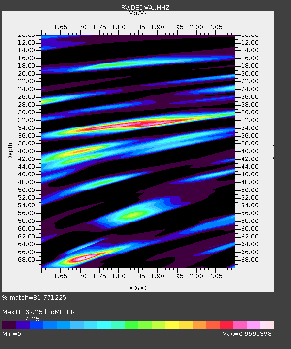
| Estimated Moho Depth: |
67.25 km |
| Estimated Crust Vp/Vs: |
1.71 |
| Assumed Crust Vp: |
6.444 km/s |
| Estimated Crust Vs: |
3.763 km/s |
| Estimated Crust Poisson's Ratio: |
0.24 |
|
| Radial Match: |
81.771225 % |
| Radial Bump: |
400 |
| Transverse Match: |
60.00348 % |
| Transverse Bump: |
400 |
| SOD ConfigId: |
13570011 |
| Insert Time: |
2019-05-01 11:14:08.819 +0000 |
| GWidth: |
2.5 |
| Max Bumps: |
400 |
| Tol: |
0.001 |
|

Signal To Noise
| Channel | StoN | STA | LTA |
| RV:DEDWA: :HHZ:20181010T21:01:09.400024Z | 9.039217 | 1.5087013E-6 | 1.6690619E-7 |
| RV:DEDWA: :HHN:20181010T21:01:09.400024Z | 1.0100111 | 3.1399782E-7 | 3.1088553E-7 |
| RV:DEDWA: :HHE:20181010T21:01:09.400024Z | 3.961957 | 6.4140113E-7 | 1.6188997E-7 |
| Arrivals |
| Ps | 7.6 SECOND |
| PpPs | 28 SECOND |
| PsPs/PpSs | 35 SECOND |


