You are here: Home > Network List > TA - USArray Transportable Network (new EarthScope stations) Stations List
> Station G23K Bananza Creek, AK, USA > Earthquake Result Viewer
G23K Bananza Creek, AK, USA - Earthquake Result Viewer

| Earthquake location: |
New Britain Region, P.N.G. |
| Earthquake latitude/longitude: |
-5.9/151.4 |
| Earthquake time(UTC): |
2018/10/10 (283) 20:48:20 GMT |
| Earthquake Depth: |
33 km |
| Earthquake Magnitude: |
7.3 Mi |
| Earthquake Catalog/Contributor: |
NEIC PDE/at |
|
| Network: |
TA USArray Transportable Network (new EarthScope stations) |
| Station: |
G23K Bananza Creek, AK, USA |
| Lat/Lon: |
66.71 N/150.02 W |
| Elevation: |
746 m |
|
| Distance: |
83.5 deg |
| Az: |
19.966 deg |
| Baz: |
238.682 deg |
| Ray Param: |
0.04607216 |
| Estimated Moho Depth: |
33.75 km |
| Estimated Crust Vp/Vs: |
1.83 |
| Assumed Crust Vp: |
6.577 km/s |
| Estimated Crust Vs: |
3.589 km/s |
| Estimated Crust Poisson's Ratio: |
0.29 |
|
| Radial Match: |
95.72529 % |
| Radial Bump: |
398 |
| Transverse Match: |
71.87438 % |
| Transverse Bump: |
400 |
| SOD ConfigId: |
13570011 |
| Insert Time: |
2019-05-01 11:15:16.799 +0000 |
| GWidth: |
2.5 |
| Max Bumps: |
400 |
| Tol: |
0.001 |
|
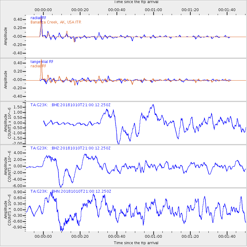
Signal To Noise
| Channel | StoN | STA | LTA |
| TA:G23K: :BHZ:20181010T21:00:12.250Z | 18.112743 | 2.5792378E-6 | 1.4239907E-7 |
| TA:G23K: :BHN:20181010T21:00:12.250Z | 4.6813083 | 5.988533E-7 | 1.2792435E-7 |
| TA:G23K: :BHE:20181010T21:00:12.250Z | 8.262402 | 8.8460337E-7 | 1.07063705E-7 |
| Arrivals |
| Ps | 4.4 SECOND |
| PpPs | 14 SECOND |
| PsPs/PpSs | 19 SECOND |


