You are here: Home > Network List > TA - USArray Transportable Network (new EarthScope stations) Stations List
> Station G25K Bearman Lake, AK, USA > Earthquake Result Viewer
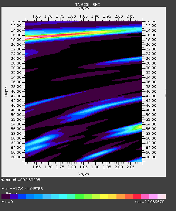
G25K Bearman Lake, AK, USA - Earthquake Result Viewer
| Earthquake location: |
New Britain Region, P.N.G. |
| Earthquake latitude/longitude: |
-5.9/151.4 |
| Earthquake time(UTC): |
2018/10/10 (283) 20:48:20 GMT |
| Earthquake Depth: |
33 km |
| Earthquake Magnitude: |
7.3 Mi |
| Earthquake Catalog/Contributor: |
NEIC PDE/at |
|
| Network: |
TA USArray Transportable Network (new EarthScope stations) |
| Station: |
G25K Bearman Lake, AK, USA |
| Lat/Lon: |
66.77 N/146.10 W |
| Elevation: |
146 m |
|
| Distance: |
84.9 deg |
| Az: |
20.689 deg |
| Baz: |
242.355 deg |
| Ray Param: |
0.04509165 |
| Estimated Moho Depth: |
17.0 km |
| Estimated Crust Vp/Vs: |
1.60 |
| Assumed Crust Vp: |
6.522 km/s |
| Estimated Crust Vs: |
4.076 km/s |
| Estimated Crust Poisson's Ratio: |
0.18 |
|
| Radial Match: |
89.168205 % |
| Radial Bump: |
400 |
| Transverse Match: |
78.12615 % |
| Transverse Bump: |
400 |
| SOD ConfigId: |
13570011 |
| Insert Time: |
2019-05-01 11:15:18.491 +0000 |
| GWidth: |
2.5 |
| Max Bumps: |
400 |
| Tol: |
0.001 |
|

Signal To Noise
| Channel | StoN | STA | LTA |
| TA:G25K: :BHZ:20181010T21:00:19.275024Z | 5.577289 | 2.7087613E-6 | 4.85677E-7 |
| TA:G25K: :BHN:20181010T21:00:19.275024Z | 1.3830186 | 1.199259E-6 | 8.671315E-7 |
| TA:G25K: :BHE:20181010T21:00:19.275024Z | 3.328488 | 1.54176E-6 | 4.6320127E-7 |
| Arrivals |
| Ps | 1.6 SECOND |
| PpPs | 6.6 SECOND |
| PsPs/PpSs | 8.2 SECOND |


