You are here: Home > Network List > TA - USArray Transportable Network (new EarthScope stations) Stations List
> Station I28M Miner Creek, YT, CAN > Earthquake Result Viewer
I28M Miner Creek, YT, CAN - Earthquake Result Viewer
| Earthquake location: |
New Britain Region, P.N.G. |
| Earthquake latitude/longitude: |
-5.9/151.4 |
| Earthquake time(UTC): |
2018/10/10 (283) 20:48:20 GMT |
| Earthquake Depth: |
33 km |
| Earthquake Magnitude: |
7.3 Mi |
| Earthquake Catalog/Contributor: |
NEIC PDE/at |
|
| Network: |
TA USArray Transportable Network (new EarthScope stations) |
| Station: |
I28M Miner Creek, YT, CAN |
| Lat/Lon: |
65.45 N/139.94 W |
| Elevation: |
1188 m |
|
| Distance: |
86.6 deg |
| Az: |
22.946 deg |
| Baz: |
248.154 deg |
| Ray Param: |
0.043855377 |
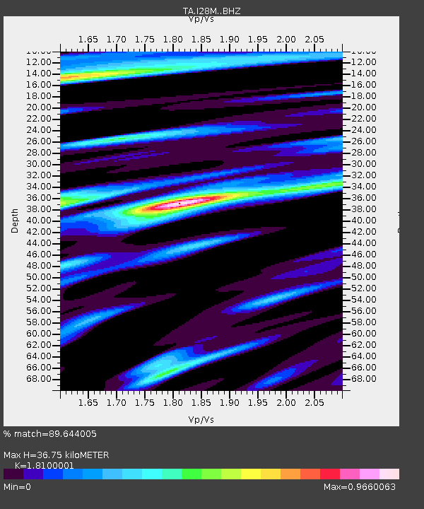
| Estimated Moho Depth: |
36.75 km |
| Estimated Crust Vp/Vs: |
1.81 |
| Assumed Crust Vp: |
6.566 km/s |
| Estimated Crust Vs: |
3.628 km/s |
| Estimated Crust Poisson's Ratio: |
0.28 |
|
| Radial Match: |
89.644005 % |
| Radial Bump: |
400 |
| Transverse Match: |
76.76153 % |
| Transverse Bump: |
400 |
| SOD ConfigId: |
13570011 |
| Insert Time: |
2019-05-01 11:15:38.681 +0000 |
| GWidth: |
2.5 |
| Max Bumps: |
400 |
| Tol: |
0.001 |
|

Signal To Noise
| Channel | StoN | STA | LTA |
| TA:I28M: :BHZ:20181010T21:00:27.849976Z | 13.782741 | 2.3263733E-6 | 1.6878889E-7 |
| TA:I28M: :BHN:20181010T21:00:27.849976Z | 2.495135 | 3.6887096E-7 | 1.4783608E-7 |
| TA:I28M: :BHE:20181010T21:00:27.849976Z | 4.8763227 | 7.203753E-7 | 1.4772921E-7 |
| Arrivals |
| Ps | 4.6 SECOND |
| PpPs | 15 SECOND |
| PsPs/PpSs | 20 SECOND |


