You are here: Home > Network List > TA - USArray Transportable Network (new EarthScope stations) Stations List
> Station M11K Mekoryuk, AK, USA > Earthquake Result Viewer
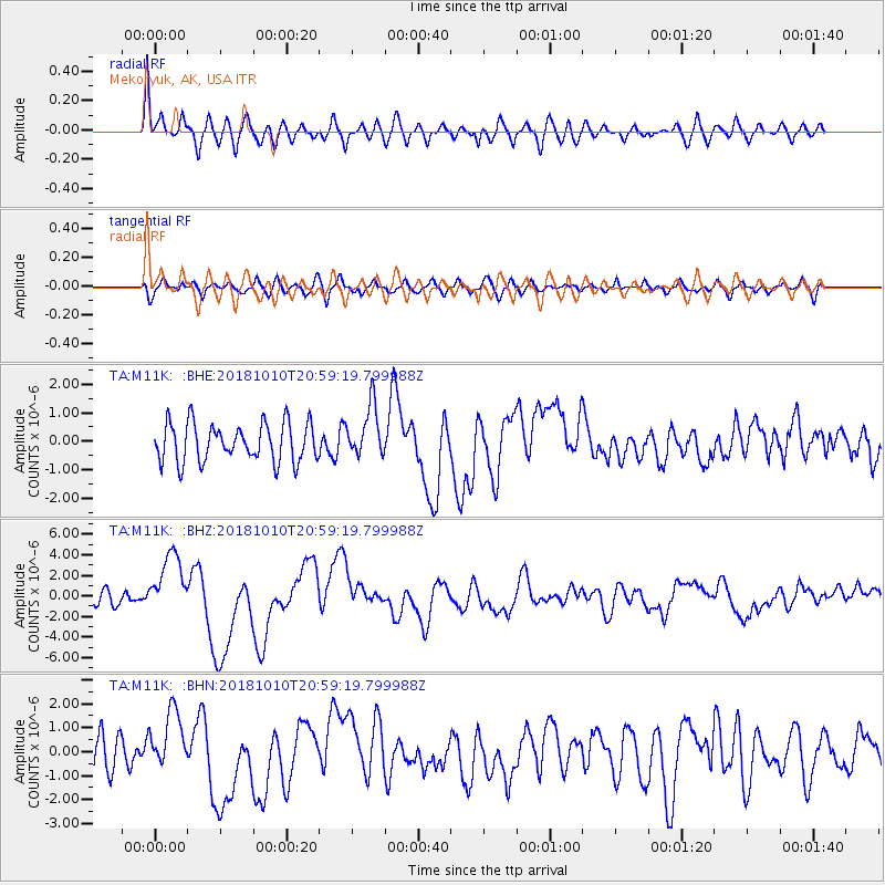
M11K Mekoryuk, AK, USA - Earthquake Result Viewer
*The percent match for this event was below the threshold and hence no stack was calculated.
| Earthquake location: |
New Britain Region, P.N.G. |
| Earthquake latitude/longitude: |
-5.9/151.4 |
| Earthquake time(UTC): |
2018/10/10 (283) 20:48:20 GMT |
| Earthquake Depth: |
33 km |
| Earthquake Magnitude: |
7.3 Mi |
| Earthquake Catalog/Contributor: |
NEIC PDE/at |
|
| Network: |
TA USArray Transportable Network (new EarthScope stations) |
| Station: |
M11K Mekoryuk, AK, USA |
| Lat/Lon: |
60.38 N/166.20 W |
| Elevation: |
3.0 m |
|
| Distance: |
74.0 deg |
| Az: |
20.394 deg |
| Baz: |
224.26 deg |
| Ray Param: |
$rayparam |
*The percent match for this event was below the threshold and hence was not used in the summary stack. |
|
| Radial Match: |
75.35438 % |
| Radial Bump: |
400 |
| Transverse Match: |
48.641678 % |
| Transverse Bump: |
400 |
| SOD ConfigId: |
13570011 |
| Insert Time: |
2019-05-01 11:16:02.980 +0000 |
| GWidth: |
2.5 |
| Max Bumps: |
400 |
| Tol: |
0.001 |
|
Signal To Noise
| Channel | StoN | STA | LTA |
| TA:M11K: :BHZ:20181010T20:59:19.799988Z | 5.536104 | 3.072463E-6 | 5.549865E-7 |
| TA:M11K: :BHN:20181010T20:59:19.799988Z | 1.5061421 | 1.2287646E-6 | 8.158358E-7 |
| TA:M11K: :BHE:20181010T20:59:19.799988Z | 1.6487442 | 1.0884493E-6 | 6.6016867E-7 |
| Arrivals |
| Ps | |
| PpPs | |
| PsPs/PpSs | |


