You are here: Home > Network List > G - GEOSCOPE Stations List
> Station TAOE Taiohae, Marquises islands > Earthquake Result Viewer
TAOE Taiohae, Marquises islands - Earthquake Result Viewer
| Earthquake location: |
Mariana Islands |
| Earthquake latitude/longitude: |
18.5/145.5 |
| Earthquake time(UTC): |
2016/07/29 (211) 21:18:25 GMT |
| Earthquake Depth: |
212 km |
| Earthquake Magnitude: |
7.7 MWW, 7.7 MWB, 7.7 MI |
| Earthquake Catalog/Contributor: |
NEIC PDE/NEIC COMCAT |
|
| Network: |
G GEOSCOPE |
| Station: |
TAOE Taiohae, Marquises islands |
| Lat/Lon: |
8.85 S/140.15 W |
| Elevation: |
800 m |
|
| Distance: |
78.2 deg |
| Az: |
103.555 deg |
| Baz: |
291.025 deg |
| Ray Param: |
0.049285173 |
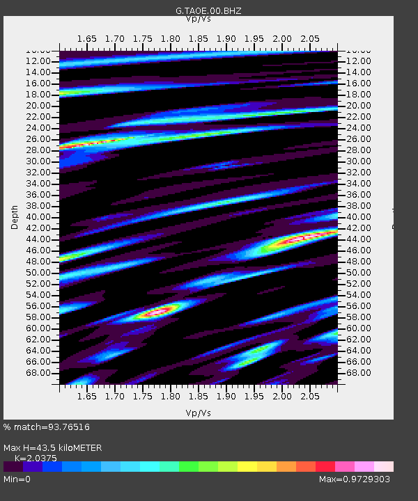
| Estimated Moho Depth: |
43.5 km |
| Estimated Crust Vp/Vs: |
2.04 |
| Assumed Crust Vp: |
4.24 km/s |
| Estimated Crust Vs: |
2.081 km/s |
| Estimated Crust Poisson's Ratio: |
0.34 |
|
| Radial Match: |
93.76516 % |
| Radial Bump: |
384 |
| Transverse Match: |
71.39741 % |
| Transverse Bump: |
400 |
| SOD ConfigId: |
1634031 |
| Insert Time: |
2016-08-12 21:22:01.499 +0000 |
| GWidth: |
2.5 |
| Max Bumps: |
400 |
| Tol: |
0.001 |
|
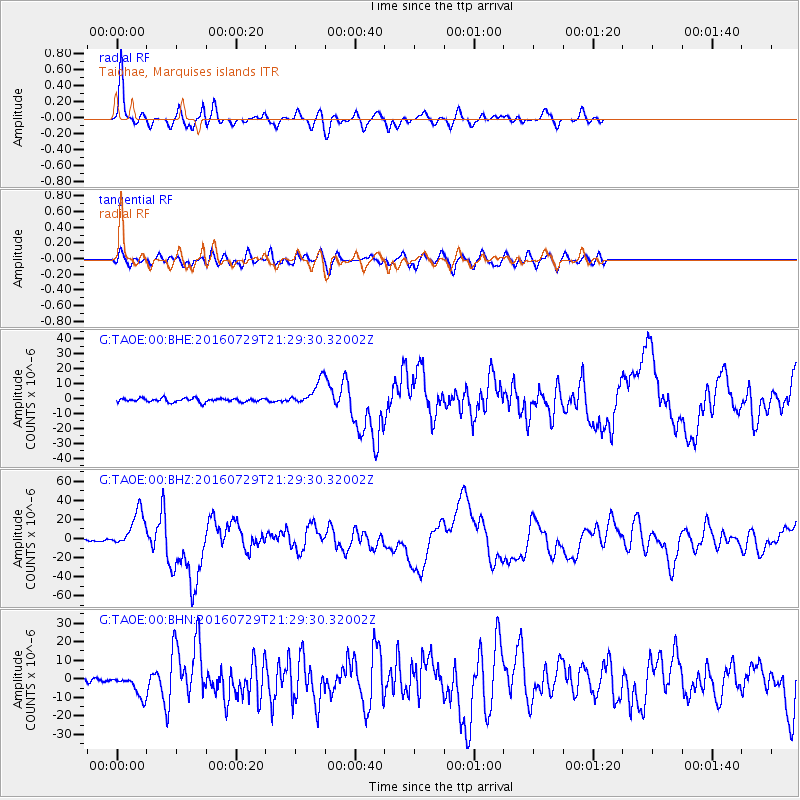
Signal To Noise
| Channel | StoN | STA | LTA |
| G:TAOE:00:BHZ:20160729T21:29:30.32002Z | 16.383705 | 1.945419E-5 | 1.1874109E-6 |
| G:TAOE:00:BHN:20160729T21:29:30.32002Z | 4.6134295 | 5.8307396E-6 | 1.2638623E-6 |
| G:TAOE:00:BHE:20160729T21:29:30.32002Z | 6.4330688 | 8.057159E-6 | 1.2524597E-6 |
| Arrivals |
| Ps | 11 SECOND |
| PpPs | 31 SECOND |
| PsPs/PpSs | 42 SECOND |


