You are here: Home > Network List > TD - TransAlta Monitoring Network Stations List
> Station TD029 Z > Earthquake Result Viewer
TD029 Z - Earthquake Result Viewer
| Earthquake location: |
New Britain Region, P.N.G. |
| Earthquake latitude/longitude: |
-5.9/151.4 |
| Earthquake time(UTC): |
2018/10/10 (283) 20:48:20 GMT |
| Earthquake Depth: |
33 km |
| Earthquake Magnitude: |
7.3 Mi |
| Earthquake Catalog/Contributor: |
NEIC PDE/at |
|
| Network: |
TD TransAlta Monitoring Network |
| Station: |
TD029 Z |
| Lat/Lon: |
52.22 N/115.20 W |
| Elevation: |
1164 m |
|
| Distance: |
96.7 deg |
| Az: |
38.199 deg |
| Baz: |
269.059 deg |
| Ray Param: |
0.040418398 |
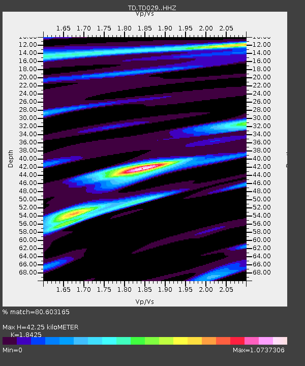
| Estimated Moho Depth: |
42.25 km |
| Estimated Crust Vp/Vs: |
1.84 |
| Assumed Crust Vp: |
6.426 km/s |
| Estimated Crust Vs: |
3.488 km/s |
| Estimated Crust Poisson's Ratio: |
0.29 |
|
| Radial Match: |
80.603165 % |
| Radial Bump: |
400 |
| Transverse Match: |
62.341057 % |
| Transverse Bump: |
400 |
| SOD ConfigId: |
13570011 |
| Insert Time: |
2019-05-01 11:16:57.321 +0000 |
| GWidth: |
2.5 |
| Max Bumps: |
400 |
| Tol: |
0.001 |
|

Signal To Noise
| Channel | StoN | STA | LTA |
| TD:TD029: :HHZ:20181010T21:01:14.700012Z | 4.634173 | 9.838241E-7 | 2.1229768E-7 |
| TD:TD029: :HH1:20181010T21:01:14.700012Z | 0.89778745 | 1.67085E-7 | 1.8610754E-7 |
| TD:TD029: :HH2:20181010T21:01:14.700012Z | 1.1927794 | 2.2671388E-7 | 1.9007194E-7 |
| Arrivals |
| Ps | 5.6 SECOND |
| PpPs | 18 SECOND |
| PsPs/PpSs | 24 SECOND |


