You are here: Home > Network List > IU - Global Seismograph Network (GSN - IRIS/USGS) Stations List
> Station AFI Afiamalu, Samoa > Earthquake Result Viewer
AFI Afiamalu, Samoa - Earthquake Result Viewer
| Earthquake location: |
Mariana Islands |
| Earthquake latitude/longitude: |
18.5/145.5 |
| Earthquake time(UTC): |
2016/07/29 (211) 21:18:25 GMT |
| Earthquake Depth: |
212 km |
| Earthquake Magnitude: |
7.7 MWW, 7.7 MWB, 7.7 MI |
| Earthquake Catalog/Contributor: |
NEIC PDE/NEIC COMCAT |
|
| Network: |
IU Global Seismograph Network (GSN - IRIS/USGS) |
| Station: |
AFI Afiamalu, Samoa |
| Lat/Lon: |
13.91 S/171.78 W |
| Elevation: |
706 m |
|
| Distance: |
53.0 deg |
| Az: |
124.465 deg |
| Baz: |
306.327 deg |
| Ray Param: |
0.065625675 |
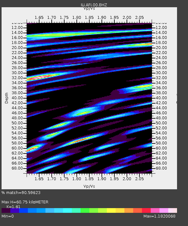
| Estimated Moho Depth: |
60.75 km |
| Estimated Crust Vp/Vs: |
1.61 |
| Assumed Crust Vp: |
4.24 km/s |
| Estimated Crust Vs: |
2.633 km/s |
| Estimated Crust Poisson's Ratio: |
0.19 |
|
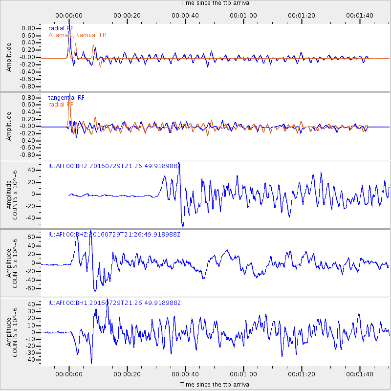
| Radial Match: |
90.59623 % |
| Radial Bump: |
400 |
| Transverse Match: |
84.17312 % |
| Transverse Bump: |
400 |
| SOD ConfigId: |
1634031 |
| Insert Time: |
2016-08-12 21:23:10.380 +0000 |
| GWidth: |
2.5 |
| Max Bumps: |
400 |
| Tol: |
0.001 |
|
Signal To Noise
| Channel | StoN | STA | LTA |
| IU:AFI:00:BHZ:20160729T21:26:49.918988Z | 26.412045 | 2.8620667E-5 | 1.0836218E-6 |
| IU:AFI:00:BH1:20160729T21:26:49.918988Z | 13.758269 | 1.280391E-5 | 9.3063375E-7 |
| IU:AFI:00:BH2:20160729T21:26:49.918988Z | 13.420699 | 1.4785314E-5 | 1.1016799E-6 |
| Arrivals |
| Ps | 9.0 SECOND |
| PpPs | 36 SECOND |
| PsPs/PpSs | 45 SECOND |


