You are here: Home > Network List > TA - USArray Transportable Network (new EarthScope stations) Stations List
> Station J14A Carey, ID, USA > Earthquake Result Viewer
J14A Carey, ID, USA - Earthquake Result Viewer
| Earthquake location: |
Virgin Islands |
| Earthquake latitude/longitude: |
19.2/-64.8 |
| Earthquake time(UTC): |
2008/10/11 (285) 10:40:14 GMT |
| Earthquake Depth: |
23 km |
| Earthquake Magnitude: |
6.1 MB, 5.9 MS, 6.1 MW, 6.0 MW |
| Earthquake Catalog/Contributor: |
WHDF/NEIC |
|
| Network: |
TA USArray Transportable Network (new EarthScope stations) |
| Station: |
J14A Carey, ID, USA |
| Lat/Lon: |
43.32 N/113.52 W |
| Elevation: |
1649 m |
|
| Distance: |
47.3 deg |
| Az: |
311.741 deg |
| Baz: |
104.873 deg |
| Ray Param: |
0.07006327 |
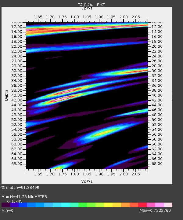
| Estimated Moho Depth: |
41.25 km |
| Estimated Crust Vp/Vs: |
1.75 |
| Assumed Crust Vp: |
6.279 km/s |
| Estimated Crust Vs: |
3.598 km/s |
| Estimated Crust Poisson's Ratio: |
0.26 |
|
| Radial Match: |
91.38499 % |
| Radial Bump: |
400 |
| Transverse Match: |
89.28503 % |
| Transverse Bump: |
400 |
| SOD ConfigId: |
2556 |
| Insert Time: |
2010-03-06 16:38:31.034 +0000 |
| GWidth: |
2.5 |
| Max Bumps: |
400 |
| Tol: |
0.001 |
|

Signal To Noise
| Channel | StoN | STA | LTA |
| TA:J14A: :BHZ:20081011T10:48:14.674014Z | 9.033895 | 2.414798E-6 | 2.6730422E-7 |
| TA:J14A: :BHN:20081011T10:48:14.674014Z | 1.2208405 | 3.3335195E-7 | 2.730512E-7 |
| TA:J14A: :BHE:20081011T10:48:14.674014Z | 2.2314568 | 8.579111E-7 | 3.8446237E-7 |
| Arrivals |
| Ps | 5.2 SECOND |
| PpPs | 17 SECOND |
| PsPs/PpSs | 22 SECOND |


