You are here: Home > Network List > TA - USArray Transportable Network (new EarthScope stations) Stations List
> Station J14A Carey, ID, USA > Earthquake Result Viewer
J14A Carey, ID, USA - Earthquake Result Viewer
| Earthquake location: |
Vanuatu Islands |
| Earthquake latitude/longitude: |
-13.5/167.0 |
| Earthquake time(UTC): |
2008/09/08 (252) 18:52:06 GMT |
| Earthquake Depth: |
110 km |
| Earthquake Magnitude: |
6.4 MB, 6.9 MW, 6.9 MW |
| Earthquake Catalog/Contributor: |
WHDF/NEIC |
|
| Network: |
TA USArray Transportable Network (new EarthScope stations) |
| Station: |
J14A Carey, ID, USA |
| Lat/Lon: |
43.32 N/113.52 W |
| Elevation: |
1649 m |
|
| Distance: |
91.7 deg |
| Az: |
45.883 deg |
| Baz: |
253.116 deg |
| Ray Param: |
0.041525852 |
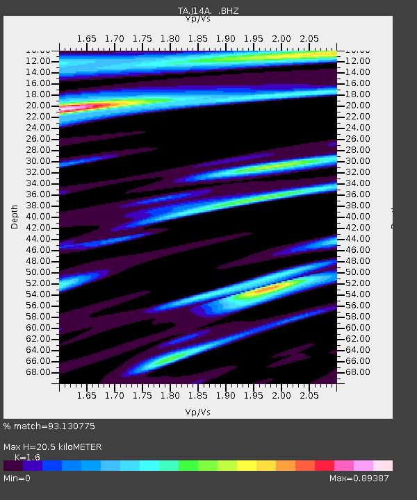
| Estimated Moho Depth: |
20.5 km |
| Estimated Crust Vp/Vs: |
1.60 |
| Assumed Crust Vp: |
6.279 km/s |
| Estimated Crust Vs: |
3.924 km/s |
| Estimated Crust Poisson's Ratio: |
0.18 |
|
| Radial Match: |
93.130775 % |
| Radial Bump: |
400 |
| Transverse Match: |
81.8674 % |
| Transverse Bump: |
400 |
| SOD ConfigId: |
2560 |
| Insert Time: |
2010-03-06 16:38:36.792 +0000 |
| GWidth: |
2.5 |
| Max Bumps: |
400 |
| Tol: |
0.001 |
|

Signal To Noise
| Channel | StoN | STA | LTA |
| TA:J14A: :BHZ:20080908T19:04:30.675017Z | 35.674297 | 3.8855815E-6 | 1.0891823E-7 |
| TA:J14A: :BHN:20080908T19:04:30.675017Z | 4.501048 | 4.4989122E-7 | 9.995254E-8 |
| TA:J14A: :BHE:20080908T19:04:30.675017Z | 9.866338 | 1.1149306E-6 | 1.1300349E-7 |
| Arrivals |
| Ps | 2.0 SECOND |
| PpPs | 8.3 SECOND |
| PsPs/PpSs | 10 SECOND |


