You are here: Home > Network List > TA - USArray Transportable Network (new EarthScope stations) Stations List
> Station J14A Carey, ID, USA > Earthquake Result Viewer
J14A Carey, ID, USA - Earthquake Result Viewer
| Earthquake location: |
Kermadec Islands Region |
| Earthquake latitude/longitude: |
-27.4/-176.3 |
| Earthquake time(UTC): |
2009/02/18 (049) 21:53:45 GMT |
| Earthquake Depth: |
25 km |
| Earthquake Magnitude: |
6.8 MB, 7.2 MS, 6.9 MW, 6.9 MW |
| Earthquake Catalog/Contributor: |
WHDF/NEIC |
|
| Network: |
TA USArray Transportable Network (new EarthScope stations) |
| Station: |
J14A Carey, ID, USA |
| Lat/Lon: |
43.32 N/113.52 W |
| Elevation: |
1649 m |
|
| Distance: |
91.0 deg |
| Az: |
40.485 deg |
| Baz: |
232.259 deg |
| Ray Param: |
0.041633356 |
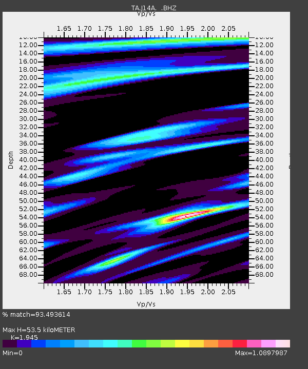
| Estimated Moho Depth: |
53.5 km |
| Estimated Crust Vp/Vs: |
1.95 |
| Assumed Crust Vp: |
6.279 km/s |
| Estimated Crust Vs: |
3.228 km/s |
| Estimated Crust Poisson's Ratio: |
0.32 |
|
| Radial Match: |
93.493614 % |
| Radial Bump: |
322 |
| Transverse Match: |
91.2958 % |
| Transverse Bump: |
286 |
| SOD ConfigId: |
2658 |
| Insert Time: |
2010-03-06 16:38:50.028 +0000 |
| GWidth: |
2.5 |
| Max Bumps: |
400 |
| Tol: |
0.001 |
|
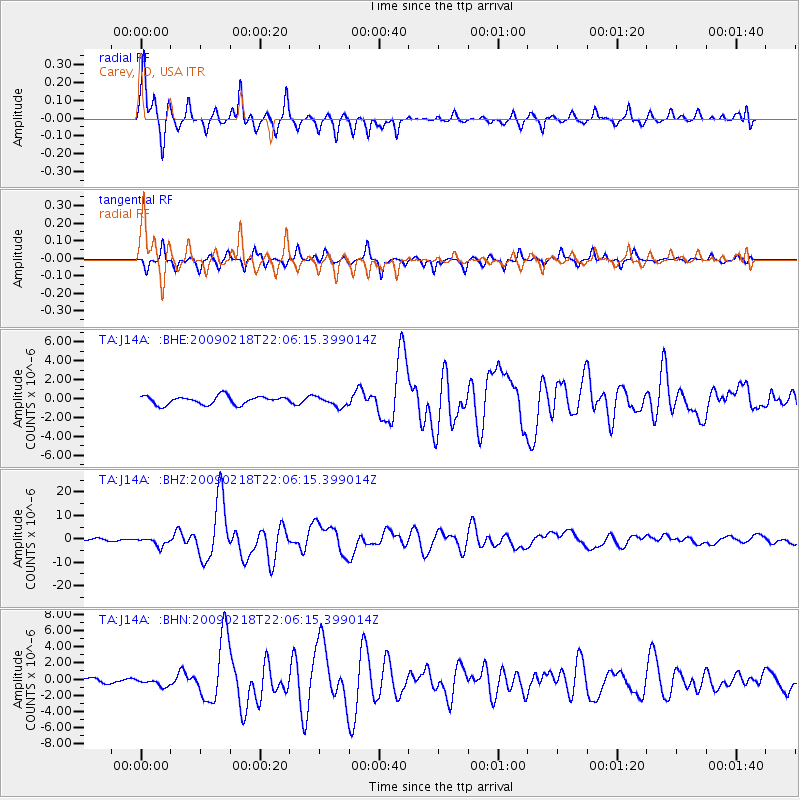
Signal To Noise
| Channel | StoN | STA | LTA |
| TA:J14A: :BHZ:20090218T22:06:15.399014Z | 4.002903 | 1.8576184E-6 | 4.6406777E-7 |
| TA:J14A: :BHN:20090218T22:06:15.399014Z | 2.0947316 | 4.891958E-7 | 2.335363E-7 |
| TA:J14A: :BHE:20090218T22:06:15.399014Z | 1.2066768 | 5.309088E-7 | 4.3997596E-7 |
| Arrivals |
| Ps | 8.2 SECOND |
| PpPs | 25 SECOND |
| PsPs/PpSs | 33 SECOND |


