You are here: Home > Network List > AZ - ANZA Regional Network Stations List
> Station SMER AZ.SMER > Earthquake Result Viewer
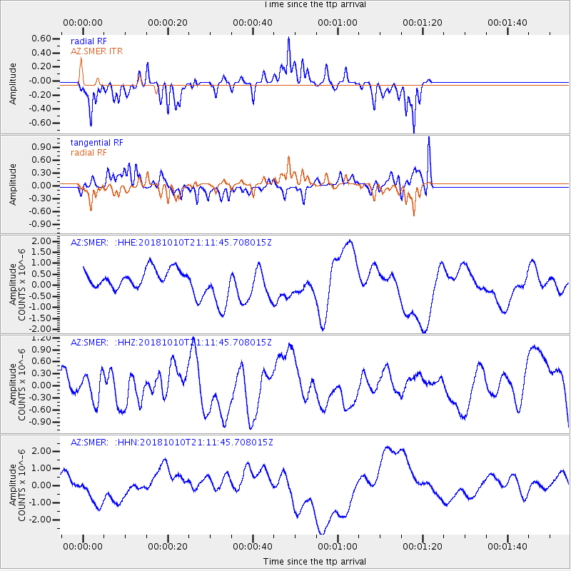
SMER AZ.SMER - Earthquake Result Viewer
*The percent match for this event was below the threshold and hence no stack was calculated.
| Earthquake location: |
New Britain Region, P.N.G. |
| Earthquake latitude/longitude: |
-6.0/151.1 |
| Earthquake time(UTC): |
2018/10/10 (283) 20:59:01 GMT |
| Earthquake Depth: |
49 km |
| Earthquake Magnitude: |
5.7 mb |
| Earthquake Catalog/Contributor: |
NEIC PDE/us |
|
| Network: |
AZ ANZA Regional Network |
| Station: |
SMER AZ.SMER |
| Lat/Lon: |
33.46 N/117.17 W |
| Elevation: |
355 m |
|
| Distance: |
94.7 deg |
| Az: |
56.975 deg |
| Baz: |
265.984 deg |
| Ray Param: |
$rayparam |
*The percent match for this event was below the threshold and hence was not used in the summary stack. |
|
| Radial Match: |
65.90585 % |
| Radial Bump: |
264 |
| Transverse Match: |
53.631363 % |
| Transverse Bump: |
335 |
| SOD ConfigId: |
13570011 |
| Insert Time: |
2019-05-01 11:20:40.069 +0000 |
| GWidth: |
2.5 |
| Max Bumps: |
400 |
| Tol: |
0.001 |
|
Signal To Noise
| Channel | StoN | STA | LTA |
| AZ:SMER: :HHZ:20181010T21:11:45.708015Z | 0.8357118 | 3.3451656E-7 | 4.002774E-7 |
| AZ:SMER: :HHN:20181010T21:11:45.708015Z | 1.0930126 | 1.0540349E-6 | 9.643392E-7 |
| AZ:SMER: :HHE:20181010T21:11:45.708015Z | 2.974071 | 1.0843085E-6 | 3.645873E-7 |
| Arrivals |
| Ps | |
| PpPs | |
| PsPs/PpSs | |


