You are here: Home > Network List > TS - TERRAscope (Southern California Seismic Network) Stations List
> Station BAR Barrett Dam, California, USA > Earthquake Result Viewer
BAR Barrett Dam, California, USA - Earthquake Result Viewer
| Earthquake location: |
Colombia |
| Earthquake latitude/longitude: |
4.2/-76.6 |
| Earthquake time(UTC): |
1995/02/08 (039) 18:40:25 GMT |
| Earthquake Depth: |
69 km |
| Earthquake Magnitude: |
6.3 MB, 6.4 UNKNOWN, 6.0 MD |
| Earthquake Catalog/Contributor: |
WHDF/NEIC |
|
| Network: |
TS TERRAscope (Southern California Seismic Network) |
| Station: |
BAR Barrett Dam, California, USA |
| Lat/Lon: |
32.68 N/116.67 W |
| Elevation: |
548 m |
|
| Distance: |
46.9 deg |
| Az: |
312.061 deg |
| Baz: |
118.591 deg |
| Ray Param: |
0.07010999 |
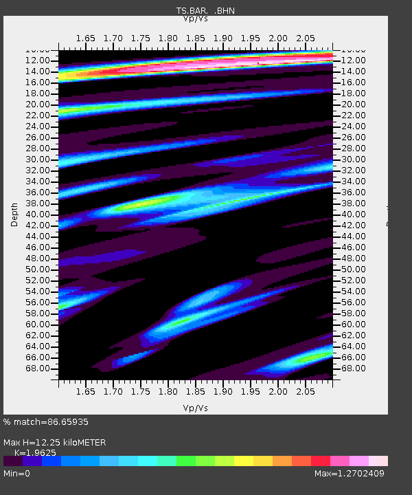
| Estimated Moho Depth: |
12.25 km |
| Estimated Crust Vp/Vs: |
1.96 |
| Assumed Crust Vp: |
6.264 km/s |
| Estimated Crust Vs: |
3.192 km/s |
| Estimated Crust Poisson's Ratio: |
0.32 |
|
| Radial Match: |
86.65935 % |
| Radial Bump: |
400 |
| Transverse Match: |
64.56981 % |
| Transverse Bump: |
400 |
| SOD ConfigId: |
6273 |
| Insert Time: |
2010-02-26 13:58:06.839 +0000 |
| GWidth: |
2.5 |
| Max Bumps: |
400 |
| Tol: |
0.001 |
|
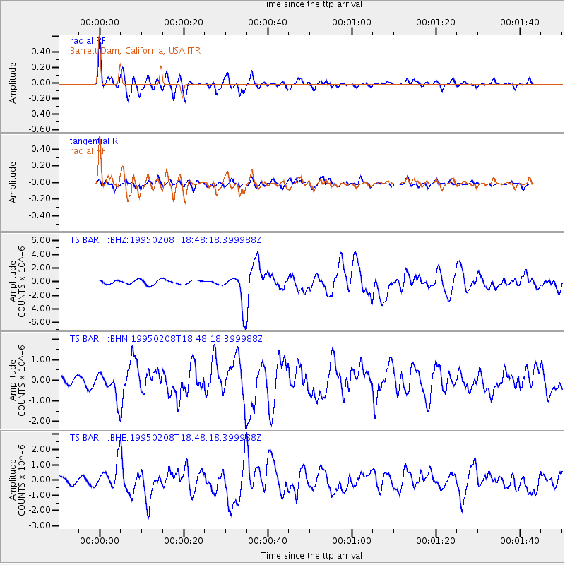
Signal To Noise
| Channel | StoN | STA | LTA |
| TS:BAR: :BHN:19950208T18:48:18.399988Z | 3.853869 | 6.9767134E-7 | 1.8103141E-7 |
| TS:BAR: :BHE:19950208T18:48:18.399988Z | 3.7282104 | 9.196234E-7 | 2.466662E-7 |
| TS:BAR: :BHZ:19950208T18:48:18.399988Z | 8.530476 | 2.6517528E-6 | 3.1085636E-7 |
| Arrivals |
| Ps | 2.0 SECOND |
| PpPs | 5.5 SECOND |
| PsPs/PpSs | 7.5 SECOND |


