You are here: Home > Network List > TA - USArray Transportable Network (new EarthScope stations) Stations List
> Station J14A Carey, ID, USA > Earthquake Result Viewer
J14A Carey, ID, USA - Earthquake Result Viewer
| Earthquake location: |
Santa Cruz Islands |
| Earthquake latitude/longitude: |
-11.6/165.8 |
| Earthquake time(UTC): |
2007/09/02 (245) 01:05:18 GMT |
| Earthquake Depth: |
35 km |
| Earthquake Magnitude: |
5.9 MB, 7.3 MS, 7.2 MW, 6.9 ME |
| Earthquake Catalog/Contributor: |
WHDF/NEIC |
|
| Network: |
TA USArray Transportable Network (new EarthScope stations) |
| Station: |
J14A Carey, ID, USA |
| Lat/Lon: |
43.32 N/113.52 W |
| Elevation: |
1649 m |
|
| Distance: |
91.2 deg |
| Az: |
46.088 deg |
| Baz: |
255.285 deg |
| Ray Param: |
0.04161283 |
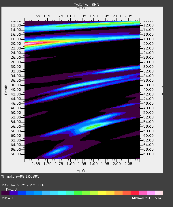
| Estimated Moho Depth: |
19.75 km |
| Estimated Crust Vp/Vs: |
1.60 |
| Assumed Crust Vp: |
6.279 km/s |
| Estimated Crust Vs: |
3.924 km/s |
| Estimated Crust Poisson's Ratio: |
0.18 |
|
| Radial Match: |
98.106895 % |
| Radial Bump: |
214 |
| Transverse Match: |
78.817795 % |
| Transverse Bump: |
400 |
| SOD ConfigId: |
2564 |
| Insert Time: |
2010-03-06 16:39:10.500 +0000 |
| GWidth: |
2.5 |
| Max Bumps: |
400 |
| Tol: |
0.001 |
|

Signal To Noise
| Channel | StoN | STA | LTA |
| TA:J14A: :BHN:20070902T01:17:48.449011Z | 4.3240848 | 3.1299248E-7 | 7.238353E-8 |
| TA:J14A: :BHE:20070902T01:17:48.449011Z | 14.185589 | 7.9238987E-7 | 5.585879E-8 |
| TA:J14A: :BHZ:20070902T01:17:48.449011Z | 25.130686 | 2.1765559E-6 | 8.660949E-8 |
| Arrivals |
| Ps | 1.9 SECOND |
| PpPs | 8.0 SECOND |
| PsPs/PpSs | 9.9 SECOND |


