You are here: Home > Network List > TA - USArray Transportable Network (new EarthScope stations) Stations List
> Station J14A Carey, ID, USA > Earthquake Result Viewer
J14A Carey, ID, USA - Earthquake Result Viewer
| Earthquake location: |
Kuril Islands |
| Earthquake latitude/longitude: |
49.7/154.3 |
| Earthquake time(UTC): |
2007/08/28 (240) 01:16:04 GMT |
| Earthquake Depth: |
116 km |
| Earthquake Magnitude: |
5.5 MB, 5.6 MW |
| Earthquake Catalog/Contributor: |
WHDF/NEIC |
|
| Network: |
TA USArray Transportable Network (new EarthScope stations) |
| Station: |
J14A Carey, ID, USA |
| Lat/Lon: |
43.32 N/113.52 W |
| Elevation: |
1649 m |
|
| Distance: |
59.9 deg |
| Az: |
57.464 deg |
| Baz: |
311.389 deg |
| Ray Param: |
0.061555184 |
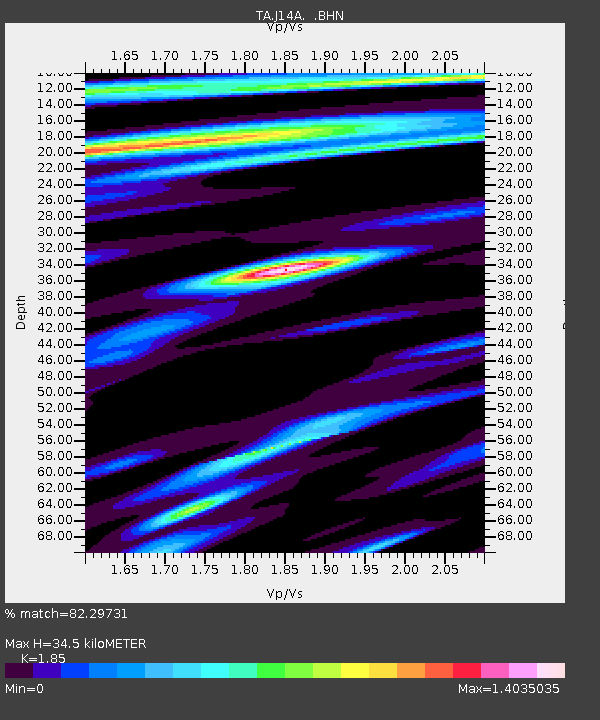
| Estimated Moho Depth: |
34.5 km |
| Estimated Crust Vp/Vs: |
1.85 |
| Assumed Crust Vp: |
6.279 km/s |
| Estimated Crust Vs: |
3.394 km/s |
| Estimated Crust Poisson's Ratio: |
0.29 |
|
| Radial Match: |
82.29731 % |
| Radial Bump: |
400 |
| Transverse Match: |
64.351906 % |
| Transverse Bump: |
400 |
| SOD ConfigId: |
2564 |
| Insert Time: |
2010-03-06 16:39:11.979 +0000 |
| GWidth: |
2.5 |
| Max Bumps: |
400 |
| Tol: |
0.001 |
|

Signal To Noise
| Channel | StoN | STA | LTA |
| TA:J14A: :BHN:20070828T01:25:27.525007Z | 1.3096132 | 8.6414005E-8 | 6.598437E-8 |
| TA:J14A: :BHE:20070828T01:25:27.525007Z | 1.262693 | 1.0209718E-7 | 8.0856694E-8 |
| TA:J14A: :BHZ:20070828T01:25:27.525007Z | 4.196844 | 3.859077E-7 | 9.1951875E-8 |
| Arrivals |
| Ps | 4.9 SECOND |
| PpPs | 15 SECOND |
| PsPs/PpSs | 20 SECOND |


