You are here: Home > Network List > IW - Intermountain West Stations List
> Station PLID Pearl Lake, Idaho, USA > Earthquake Result Viewer
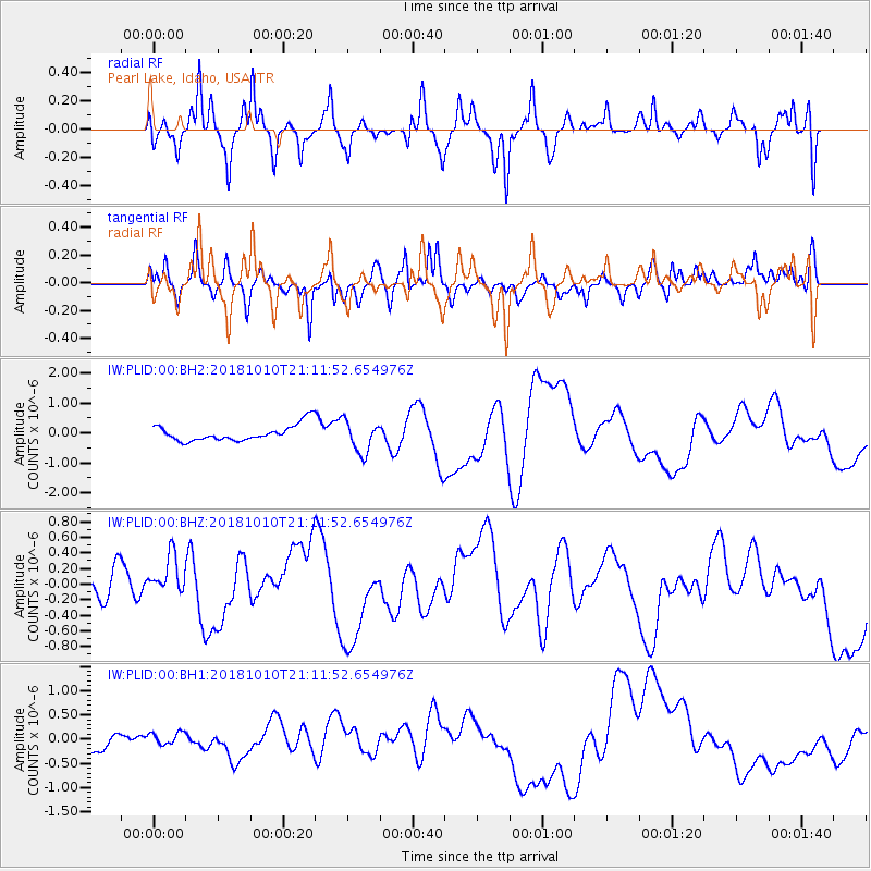
PLID Pearl Lake, Idaho, USA - Earthquake Result Viewer
*The percent match for this event was below the threshold and hence no stack was calculated.
| Earthquake location: |
New Britain Region, P.N.G. |
| Earthquake latitude/longitude: |
-6.0/151.1 |
| Earthquake time(UTC): |
2018/10/10 (283) 20:59:01 GMT |
| Earthquake Depth: |
49 km |
| Earthquake Magnitude: |
5.7 mb |
| Earthquake Catalog/Contributor: |
NEIC PDE/us |
|
| Network: |
IW Intermountain West |
| Station: |
PLID Pearl Lake, Idaho, USA |
| Lat/Lon: |
45.09 N/116.00 W |
| Elevation: |
2164 m |
|
| Distance: |
96.3 deg |
| Az: |
45.375 deg |
| Baz: |
267.839 deg |
| Ray Param: |
$rayparam |
*The percent match for this event was below the threshold and hence was not used in the summary stack. |
|
| Radial Match: |
33.815132 % |
| Radial Bump: |
335 |
| Transverse Match: |
39.98081 % |
| Transverse Bump: |
376 |
| SOD ConfigId: |
13570011 |
| Insert Time: |
2019-05-01 11:22:05.065 +0000 |
| GWidth: |
2.5 |
| Max Bumps: |
400 |
| Tol: |
0.001 |
|
Signal To Noise
| Channel | StoN | STA | LTA |
| IW:PLID:00:BHZ:20181010T21:11:52.654976Z | 1.2971104 | 2.5465008E-7 | 1.9632105E-7 |
| IW:PLID:00:BH1:20181010T21:11:52.654976Z | 0.9674936 | 1.3326479E-7 | 1.377423E-7 |
| IW:PLID:00:BH2:20181010T21:11:52.654976Z | 1.8122553 | 5.181217E-7 | 2.8589884E-7 |
| Arrivals |
| Ps | |
| PpPs | |
| PsPs/PpSs | |


