You are here: Home > Network List > IU - Global Seismograph Network (GSN - IRIS/USGS) Stations List
> Station POHA Pohakuloa, Hawaii, USA > Earthquake Result Viewer
POHA Pohakuloa, Hawaii, USA - Earthquake Result Viewer

| Earthquake location: |
Mariana Islands |
| Earthquake latitude/longitude: |
18.5/145.5 |
| Earthquake time(UTC): |
2016/07/29 (211) 21:18:25 GMT |
| Earthquake Depth: |
212 km |
| Earthquake Magnitude: |
7.7 MWW, 7.7 MWB, 7.7 MI |
| Earthquake Catalog/Contributor: |
NEIC PDE/NEIC COMCAT |
|
| Network: |
IU Global Seismograph Network (GSN - IRIS/USGS) |
| Station: |
POHA Pohakuloa, Hawaii, USA |
| Lat/Lon: |
19.76 N/155.53 W |
| Elevation: |
1990 m |
|
| Distance: |
55.4 deg |
| Az: |
78.41 deg |
| Baz: |
279.277 deg |
| Ray Param: |
0.064060956 |
| Estimated Moho Depth: |
11.75 km |
| Estimated Crust Vp/Vs: |
1.95 |
| Assumed Crust Vp: |
5.195 km/s |
| Estimated Crust Vs: |
2.661 km/s |
| Estimated Crust Poisson's Ratio: |
0.32 |
|
| Radial Match: |
89.910934 % |
| Radial Bump: |
400 |
| Transverse Match: |
87.98954 % |
| Transverse Bump: |
400 |
| SOD ConfigId: |
1634031 |
| Insert Time: |
2016-08-12 21:24:30.088 +0000 |
| GWidth: |
2.5 |
| Max Bumps: |
400 |
| Tol: |
0.001 |
|
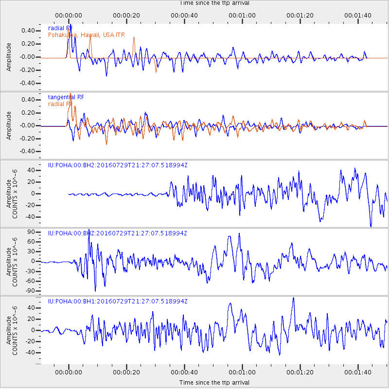
Signal To Noise
| Channel | StoN | STA | LTA |
| IU:POHA:00:BHZ:20160729T21:27:07.518994Z | 9.991456 | 1.3117497E-5 | 1.3128714E-6 |
| IU:POHA:00:BH1:20160729T21:27:07.518994Z | 1.9223399 | 3.5297678E-6 | 1.836183E-6 |
| IU:POHA:00:BH2:20160729T21:27:07.518994Z | 1.3297846 | 1.6000051E-6 | 1.2032062E-6 |
| Arrivals |
| Ps | 2.2 SECOND |
| PpPs | 6.5 SECOND |
| PsPs/PpSs | 8.7 SECOND |


