You are here: Home > Network List > TA - USArray Transportable Network (new EarthScope stations) Stations List
> Station J14A Carey, ID, USA > Earthquake Result Viewer
J14A Carey, ID, USA - Earthquake Result Viewer
| Earthquake location: |
South Of Panama |
| Earthquake latitude/longitude: |
5.7/-82.8 |
| Earthquake time(UTC): |
2009/03/12 (071) 23:23:34 GMT |
| Earthquake Depth: |
9.0 km |
| Earthquake Magnitude: |
6.1 MB, 5.9 MS, 6.3 MW, 6.2 MW |
| Earthquake Catalog/Contributor: |
WHDF/NEIC |
|
| Network: |
TA USArray Transportable Network (new EarthScope stations) |
| Station: |
J14A Carey, ID, USA |
| Lat/Lon: |
43.32 N/113.52 W |
| Elevation: |
1649 m |
|
| Distance: |
46.3 deg |
| Az: |
328.902 deg |
| Baz: |
135.227 deg |
| Ray Param: |
0.07075875 |
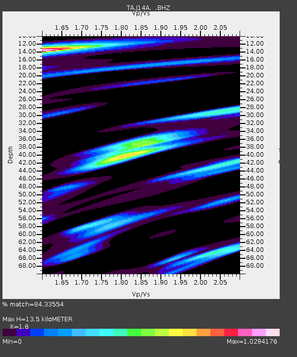
| Estimated Moho Depth: |
13.5 km |
| Estimated Crust Vp/Vs: |
1.60 |
| Assumed Crust Vp: |
6.279 km/s |
| Estimated Crust Vs: |
3.924 km/s |
| Estimated Crust Poisson's Ratio: |
0.18 |
|
| Radial Match: |
84.33554 % |
| Radial Bump: |
400 |
| Transverse Match: |
70.99759 % |
| Transverse Bump: |
400 |
| SOD ConfigId: |
2658 |
| Insert Time: |
2010-03-06 16:39:23.925 +0000 |
| GWidth: |
2.5 |
| Max Bumps: |
400 |
| Tol: |
0.001 |
|

Signal To Noise
| Channel | StoN | STA | LTA |
| TA:J14A: :BHZ:20090312T23:31:29.473992Z | 7.410934 | 1.3136656E-6 | 1.7726047E-7 |
| TA:J14A: :BHN:20090312T23:31:29.473992Z | 1.7821517 | 5.7414405E-7 | 3.221634E-7 |
| TA:J14A: :BHE:20090312T23:31:29.473992Z | 1.7345119 | 5.2476315E-7 | 3.0254225E-7 |
| Arrivals |
| Ps | 1.4 SECOND |
| PpPs | 5.2 SECOND |
| PsPs/PpSs | 6.6 SECOND |


