You are here: Home > Network List > TA - USArray Transportable Network (new EarthScope stations) Stations List
> Station J14A Carey, ID, USA > Earthquake Result Viewer
J14A Carey, ID, USA - Earthquake Result Viewer
| Earthquake location: |
Off Coast Of Ecuador |
| Earthquake latitude/longitude: |
1.4/-85.2 |
| Earthquake time(UTC): |
2009/05/10 (130) 01:16:06 GMT |
| Earthquake Depth: |
6.0 km |
| Earthquake Magnitude: |
5.5 MB, 5.7 MS, 6.1 MW, 6.1 MW |
| Earthquake Catalog/Contributor: |
WHDF/NEIC |
|
| Network: |
TA USArray Transportable Network (new EarthScope stations) |
| Station: |
J14A Carey, ID, USA |
| Lat/Lon: |
43.32 N/113.52 W |
| Elevation: |
1649 m |
|
| Distance: |
48.8 deg |
| Az: |
332.58 deg |
| Baz: |
140.889 deg |
| Ray Param: |
0.06912559 |
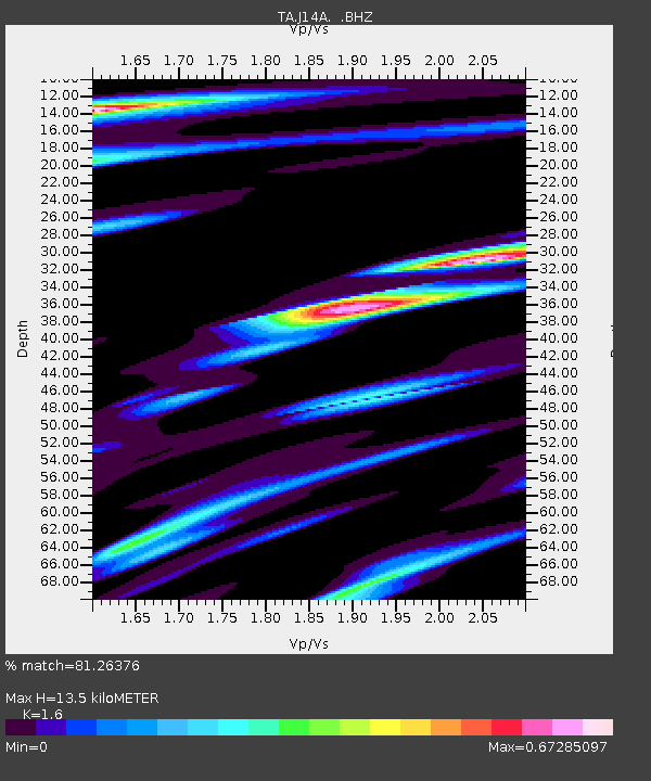
| Estimated Moho Depth: |
13.5 km |
| Estimated Crust Vp/Vs: |
1.60 |
| Assumed Crust Vp: |
6.279 km/s |
| Estimated Crust Vs: |
3.924 km/s |
| Estimated Crust Poisson's Ratio: |
0.18 |
|
| Radial Match: |
81.26376 % |
| Radial Bump: |
400 |
| Transverse Match: |
68.75204 % |
| Transverse Bump: |
400 |
| SOD ConfigId: |
2760 |
| Insert Time: |
2010-03-06 16:39:37.740 +0000 |
| GWidth: |
2.5 |
| Max Bumps: |
400 |
| Tol: |
0.001 |
|
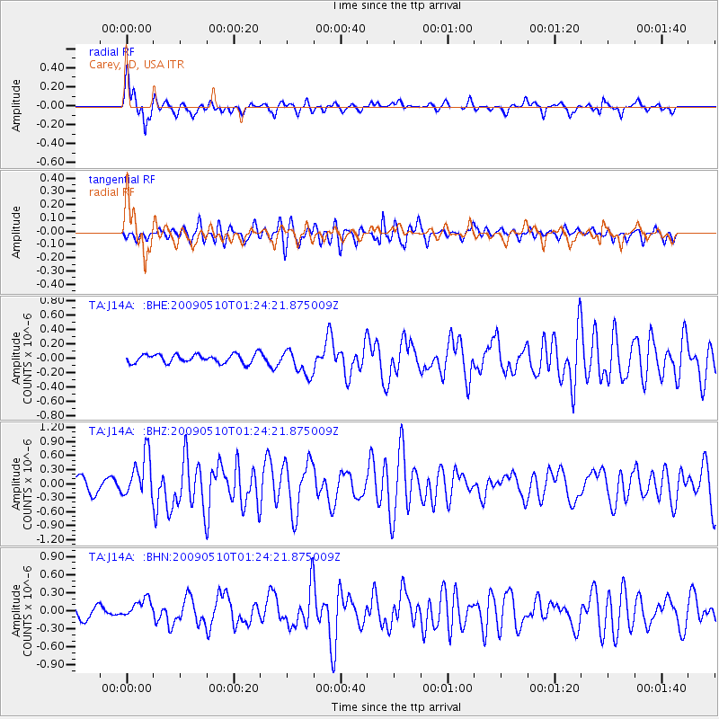
Signal To Noise
| Channel | StoN | STA | LTA |
| TA:J14A: :BHZ:20090510T01:24:21.875009Z | 3.5863926 | 4.713882E-7 | 1.3143799E-7 |
| TA:J14A: :BHN:20090510T01:24:21.875009Z | 2.087808 | 1.6042102E-7 | 7.683707E-8 |
| TA:J14A: :BHE:20090510T01:24:21.875009Z | 2.9691222 | 1.7994027E-7 | 6.060386E-8 |
| Arrivals |
| Ps | 1.4 SECOND |
| PpPs | 5.2 SECOND |
| PsPs/PpSs | 6.6 SECOND |


