You are here: Home > Network List > IU - Global Seismograph Network (GSN - IRIS/USGS) Stations List
> Station SNZO South Karori, New Zealand > Earthquake Result Viewer
SNZO South Karori, New Zealand - Earthquake Result Viewer
| Earthquake location: |
Mariana Islands |
| Earthquake latitude/longitude: |
18.5/145.5 |
| Earthquake time(UTC): |
2016/07/29 (211) 21:18:25 GMT |
| Earthquake Depth: |
212 km |
| Earthquake Magnitude: |
7.7 MWW, 7.7 MWB, 7.7 MI |
| Earthquake Catalog/Contributor: |
NEIC PDE/NEIC COMCAT |
|
| Network: |
IU Global Seismograph Network (GSN - IRIS/USGS) |
| Station: |
SNZO South Karori, New Zealand |
| Lat/Lon: |
41.31 S/174.70 E |
| Elevation: |
120 m |
|
| Distance: |
65.4 deg |
| Az: |
156.174 deg |
| Baz: |
329.415 deg |
| Ray Param: |
0.057672508 |
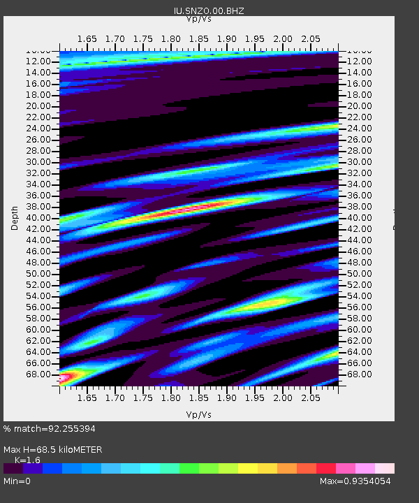
| Estimated Moho Depth: |
68.5 km |
| Estimated Crust Vp/Vs: |
1.60 |
| Assumed Crust Vp: |
6.461 km/s |
| Estimated Crust Vs: |
4.038 km/s |
| Estimated Crust Poisson's Ratio: |
0.18 |
|
| Radial Match: |
92.255394 % |
| Radial Bump: |
400 |
| Transverse Match: |
79.53344 % |
| Transverse Bump: |
400 |
| SOD ConfigId: |
1634031 |
| Insert Time: |
2016-08-12 21:24:53.300 +0000 |
| GWidth: |
2.5 |
| Max Bumps: |
400 |
| Tol: |
0.001 |
|
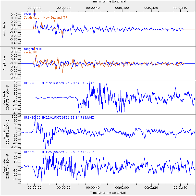
Signal To Noise
| Channel | StoN | STA | LTA |
| IU:SNZO:00:BHZ:20160729T21:28:14.518994Z | 42.14954 | 5.66436E-5 | 1.3438722E-6 |
| IU:SNZO:00:BH1:20160729T21:28:14.518994Z | 10.918029 | 1.386233E-5 | 1.2696734E-6 |
| IU:SNZO:00:BH2:20160729T21:28:14.518994Z | 17.749315 | 1.9310895E-5 | 1.0879797E-6 |
| Arrivals |
| Ps | 6.7 SECOND |
| PpPs | 26 SECOND |
| PsPs/PpSs | 33 SECOND |


