J14A Carey, ID, USA - Earthquake Result Viewer
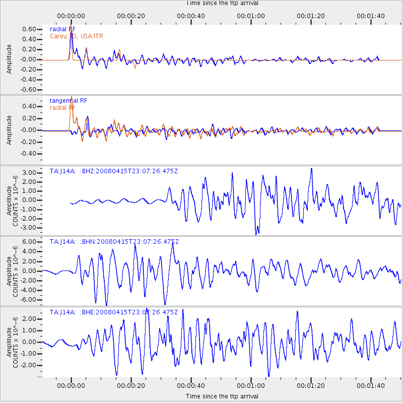
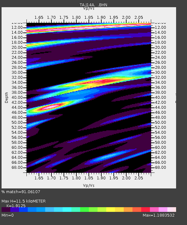
Earthquake location: Andreanof Islands, Aleutian Is.
Earthquake latitude/longitude: 51.9/-179.4
Earthquake time(UTC): 2008/04/15 (106) 22:59:51 GMT
Earthquake Depth: 10 km
Earthquake Magnitude: 6.1 MB, 6.4 MS, 6.4 MW, 6.4 MW
Earthquake Catalog/Contributor: WHDF/NEIC
Network: TA USArray Transportable Network (new EarthScope stations)
Station: J14A Carey, ID, USA
Lat/Lon: 43.32 N/113.52 W
Elevation: 1649 m
Distance: 43.8 deg
Az: 74.095 deg
Baz: 305.18 deg
Ray Param: 0.07230511
Estimated Moho Depth: 11.5 km
Estimated Crust Vp/Vs: 1.91
Assumed Crust Vp: 6.279 km/s
Estimated Crust Vs: 3.283 km/s
Estimated Crust Poisson's Ratio: 0.31
Radial Match: 91.06107 %
Radial Bump: 400
Transverse Match: 77.79438 %
Transverse Bump: 400
SOD ConfigId: 2504
Insert Time: 2010-03-06 16:39:44.262 +0000
GWidth: 2.5
Max Bumps: 400
Tol: 0.001

Signal To Noise

ChannelStoNSTALTA
TA:J14A: :BHN:20080415T23:07:26.475Z6.24246641.4264084E-62.2850075E-7
TA:J14A: :BHE:20080415T23:07:26.475Z1.5870392.785974E-71.7554541E-7
TA:J14A: :BHZ:20080415T23:07:26.475Z3.60412435.5351353E-71.5357782E-7
Arrivals
Ps1.8 SECOND
PpPs5.0 SECOND
PsPs/PpSs6.8 SECOND