You are here: Home > Network List > TA - USArray Transportable Network (new EarthScope stations) Stations List
> Station A21K Barrow, AK, USA > Earthquake Result Viewer
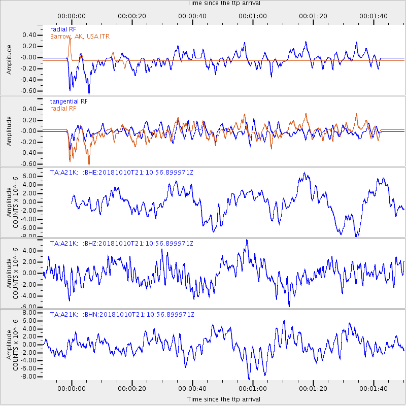
A21K Barrow, AK, USA - Earthquake Result Viewer
*The percent match for this event was below the threshold and hence no stack was calculated.
| Earthquake location: |
New Britain Region, P.N.G. |
| Earthquake latitude/longitude: |
-6.0/151.1 |
| Earthquake time(UTC): |
2018/10/10 (283) 20:59:01 GMT |
| Earthquake Depth: |
49 km |
| Earthquake Magnitude: |
5.7 mb |
| Earthquake Catalog/Contributor: |
NEIC PDE/us |
|
| Network: |
TA USArray Transportable Network (new EarthScope stations) |
| Station: |
A21K Barrow, AK, USA |
| Lat/Lon: |
71.32 N/156.62 W |
| Elevation: |
577 m |
|
| Distance: |
84.4 deg |
| Az: |
14.843 deg |
| Baz: |
232.265 deg |
| Ray Param: |
$rayparam |
*The percent match for this event was below the threshold and hence was not used in the summary stack. |
|
| Radial Match: |
81.83118 % |
| Radial Bump: |
400 |
| Transverse Match: |
47.82282 % |
| Transverse Bump: |
400 |
| SOD ConfigId: |
13570011 |
| Insert Time: |
2019-05-01 11:23:32.363 +0000 |
| GWidth: |
2.5 |
| Max Bumps: |
400 |
| Tol: |
0.001 |
|
Signal To Noise
| Channel | StoN | STA | LTA |
| TA:A21K: :BHZ:20181010T21:10:56.899971Z | 1.6058369 | 2.1672556E-6 | 1.3496114E-6 |
| TA:A21K: :BHN:20181010T21:10:56.899971Z | 1.1007534 | 1.1942386E-6 | 1.0849284E-6 |
| TA:A21K: :BHE:20181010T21:10:56.899971Z | 1.83003 | 2.9322766E-6 | 1.6023107E-6 |
| Arrivals |
| Ps | |
| PpPs | |
| PsPs/PpSs | |


