You are here: Home > Network List > TA - USArray Transportable Network (new EarthScope stations) Stations List
> Station E20K Nigu River, AK, USA > Earthquake Result Viewer
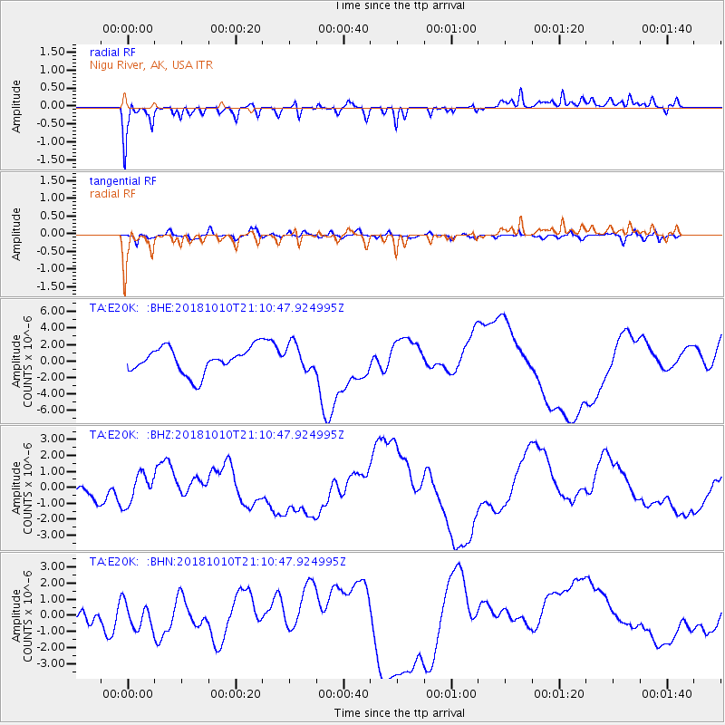
E20K Nigu River, AK, USA - Earthquake Result Viewer
*The percent match for this event was below the threshold and hence no stack was calculated.
| Earthquake location: |
New Britain Region, P.N.G. |
| Earthquake latitude/longitude: |
-6.0/151.1 |
| Earthquake time(UTC): |
2018/10/10 (283) 20:59:01 GMT |
| Earthquake Depth: |
49 km |
| Earthquake Magnitude: |
5.7 mb |
| Earthquake Catalog/Contributor: |
NEIC PDE/us |
|
| Network: |
TA USArray Transportable Network (new EarthScope stations) |
| Station: |
E20K Nigu River, AK, USA |
| Lat/Lon: |
68.26 N/156.19 W |
| Elevation: |
866 m |
|
| Distance: |
82.6 deg |
| Az: |
17.397 deg |
| Baz: |
232.957 deg |
| Ray Param: |
$rayparam |
*The percent match for this event was below the threshold and hence was not used in the summary stack. |
|
| Radial Match: |
51.340492 % |
| Radial Bump: |
400 |
| Transverse Match: |
30.806128 % |
| Transverse Bump: |
400 |
| SOD ConfigId: |
13570011 |
| Insert Time: |
2019-05-01 11:23:47.033 +0000 |
| GWidth: |
2.5 |
| Max Bumps: |
400 |
| Tol: |
0.001 |
|
Signal To Noise
| Channel | StoN | STA | LTA |
| TA:E20K: :BHZ:20181010T21:10:47.924995Z | 1.5392909 | 9.323389E-7 | 6.0569374E-7 |
| TA:E20K: :BHN:20181010T21:10:47.924995Z | 1.5621624 | 7.693189E-7 | 4.924705E-7 |
| TA:E20K: :BHE:20181010T21:10:47.924995Z | 1.050103 | 1.6505813E-6 | 1.5718281E-6 |
| Arrivals |
| Ps | |
| PpPs | |
| PsPs/PpSs | |


