You are here: Home > Network List > TA - USArray Transportable Network (new EarthScope stations) Stations List
> Station G21K Allakaket, AK, USA > Earthquake Result Viewer
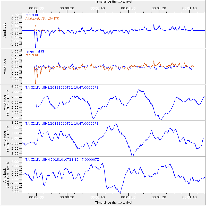
G21K Allakaket, AK, USA - Earthquake Result Viewer
*The percent match for this event was below the threshold and hence no stack was calculated.
| Earthquake location: |
New Britain Region, P.N.G. |
| Earthquake latitude/longitude: |
-6.0/151.1 |
| Earthquake time(UTC): |
2018/10/10 (283) 20:59:01 GMT |
| Earthquake Depth: |
49 km |
| Earthquake Magnitude: |
5.7 mb |
| Earthquake Catalog/Contributor: |
NEIC PDE/us |
|
| Network: |
TA USArray Transportable Network (new EarthScope stations) |
| Station: |
G21K Allakaket, AK, USA |
| Lat/Lon: |
66.52 N/153.51 W |
| Elevation: |
446 m |
|
| Distance: |
82.4 deg |
| Az: |
19.441 deg |
| Baz: |
235.697 deg |
| Ray Param: |
$rayparam |
*The percent match for this event was below the threshold and hence was not used in the summary stack. |
|
| Radial Match: |
52.959064 % |
| Radial Bump: |
400 |
| Transverse Match: |
37.076614 % |
| Transverse Bump: |
400 |
| SOD ConfigId: |
13570011 |
| Insert Time: |
2019-05-01 11:24:06.601 +0000 |
| GWidth: |
2.5 |
| Max Bumps: |
400 |
| Tol: |
0.001 |
|
Signal To Noise
| Channel | StoN | STA | LTA |
| TA:G21K: :BHZ:20181010T21:10:47.000007Z | 1.5287423 | 1.0538777E-6 | 6.8937555E-7 |
| TA:G21K: :BHN:20181010T21:10:47.000007Z | 2.3414145 | 8.6502075E-7 | 3.6944365E-7 |
| TA:G21K: :BHE:20181010T21:10:47.000007Z | 0.6906905 | 1.0054711E-6 | 1.4557477E-6 |
| Arrivals |
| Ps | |
| PpPs | |
| PsPs/PpSs | |


